Difference between revisions of "2010-04-05 33 -112"
imported>Gila Monster (→Expedition) |
imported>FippeBot m (Location) |
||
| (5 intermediate revisions by 2 users not shown) | |||
| Line 1: | Line 1: | ||
| − | |||
| − | |||
| − | |||
| − | |||
| − | |||
| − | |||
{{meetup graticule | {{meetup graticule | ||
| lat=33 | | lat=33 | ||
| Line 11: | Line 5: | ||
}} | }} | ||
| − | + | ||
__NOTOC__ | __NOTOC__ | ||
== Location == | == Location == | ||
| − | Rainbow Valley, southeast of Buckeye. Edge of | + | Rainbow Valley, southeast of Buckeye. Edge of civilization, but looks like paved road up to within a quarter-mile of the coordinates, and dirt or gravel up to within a couple hundred feet. |
== Participants == | == Participants == | ||
| Line 24: | Line 18: | ||
== Expedition == | == Expedition == | ||
| − | It looked easy enough, and almost was. It was a nice drive of about an hour, much of it through parts neither of us had traveled before. Perhaps of note to those familiar with the area, the Gila River was flowing when we crossed over it. That was neat to see. We made it to about a quarter mile from the target, paved roads the whole way. We continued on past this closest point to what had appeared on the aerial photo to be a dirt road, | + | It looked easy enough, and almost was. It was a nice drive of about an hour, much of it through parts neither of us had traveled before. Perhaps of note to those familiar with the area, the Gila River was flowing when we crossed over it. That was neat to see. We made it to about a quarter mile from the target, paved roads the whole way. We continued on past this closest point to what had appeared on the aerial photo to be a dirt road that should have taken us to within a few feet. It turned out to be exactly that, but what was not visible in the aerial photo was the barbed wire fence and the "Private Property No Trespassing" sign. Oh well. Still a fun trip. We passed through tiny Liberty, AZ, which seemed to be about a quarter mile long from end to end with the only visible structures being a church, a school, and four houses! |
| − | |||
| − | |||
== Photos == | == Photos == | ||
| − | + | ||
| − | + | ||
| − | |||
<gallery perrow="4"> | <gallery perrow="4"> | ||
| + | Image:2010-04-05 33 -112 privatesign.jpg | Tux is not pleased. | ||
| + | Image:2010-04-05 33 -112 gps.jpg | We are here. | ||
| + | Image:2010-04-05 33 -112 overthere.jpg | It's over there. | ||
</gallery> | </gallery> | ||
| − | |||
| − | |||
| − | |||
| − | + | [[Category:Expeditions]] | |
| − | |||
| − | [[Category: | ||
| − | |||
| − | |||
| − | |||
| − | |||
[[Category:Expeditions with photos]] | [[Category:Expeditions with photos]] | ||
| − | + | [[Category:Coordinates not reached]] | |
| − | |||
| − | |||
| − | |||
| − | |||
| − | [[Category:Coordinates reached]] | ||
| − | |||
| − | |||
| − | |||
| − | |||
| − | |||
[[Category:Not reached - No public access]] | [[Category:Not reached - No public access]] | ||
| − | + | {{location|US|AZ|MA}} | |
| − | |||
| − | |||
Latest revision as of 01:29, 9 August 2019
| Mon 5 Apr 2010 in 33,-112: 33.2145287, -112.4158309 geohashing.info google osm bing/os kml crox |
Location
Rainbow Valley, southeast of Buckeye. Edge of civilization, but looks like paved road up to within a quarter-mile of the coordinates, and dirt or gravel up to within a couple hundred feet.
Participants
Plans
SkinWalker and Gila Monster plan to try this one today. It'll be a bit of a drive, not much walking, and a chance to run an errand or two along the way. We're aiming for 4:00pm if anyone else wants to meet us there.
Expedition
It looked easy enough, and almost was. It was a nice drive of about an hour, much of it through parts neither of us had traveled before. Perhaps of note to those familiar with the area, the Gila River was flowing when we crossed over it. That was neat to see. We made it to about a quarter mile from the target, paved roads the whole way. We continued on past this closest point to what had appeared on the aerial photo to be a dirt road that should have taken us to within a few feet. It turned out to be exactly that, but what was not visible in the aerial photo was the barbed wire fence and the "Private Property No Trespassing" sign. Oh well. Still a fun trip. We passed through tiny Liberty, AZ, which seemed to be about a quarter mile long from end to end with the only visible structures being a church, a school, and four houses!
Photos
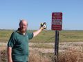
Tux is not pleased.
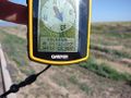
We are here.
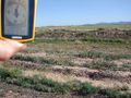
It's over there.


