Difference between revisions of "2010-04-06 45 -123"
From Geohashing
imported>Jiml (Expnd report) |
imported>FippeBot m (Location) |
||
| (One intermediate revision by one other user not shown) | |||
| Line 11: | Line 11: | ||
== Participants == | == Participants == | ||
| − | * Jim | + | * [[User:Jiml|Jim]] |
== Plans == | == Plans == | ||
| Line 38: | Line 38: | ||
[[Category:Coordinates not reached]] | [[Category:Coordinates not reached]] | ||
[[Category:Not reached - No public access]] | [[Category:Not reached - No public access]] | ||
| + | {{location|US|OR|WI}} | ||
Latest revision as of 01:31, 9 August 2019
| Tue 6 Apr 2010 in 45,-123: 45.6020716, -123.0849708 geohashing.info google osm bing/os kml crox |
Location
South and West of North Plains, Oregon
Participants
Plans
Jim is going to go and expects to find a field with no access.
Expedition
I found my way there, and it was a field full of grapevines, so no access to the hashpoint. On the way I ran into another graveyard, so I took a picture for my continuing series "The graveyards of Washington County".
I took a couple of pictures and I continued on to home to make dinner.
Photos
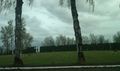
A nearby graveyard
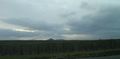
A view of the hashpoint

