Difference between revisions of "2010-07-21 36 -119"
imported>Antior |
imported>FippeBot m (Location) |
||
| (2 intermediate revisions by 2 users not shown) | |||
| Line 1: | Line 1: | ||
| − | [[Image: | + | [[Image:2010-07-21_36_-119d.jpg|thumb|left]] |
| Line 14: | Line 14: | ||
== Participants == | == Participants == | ||
| − | [[User: | + | [[User:CO2|CO2]] |
The others with me on the holiday | The others with me on the holiday | ||
| Line 40: | Line 40: | ||
[[Category:Coordinates not reached]] | [[Category:Coordinates not reached]] | ||
[[Category:Not reached - No public access]] | [[Category:Not reached - No public access]] | ||
| + | {{location|US|CA|FR}} | ||
Latest revision as of 02:54, 9 August 2019

| Wed 21 Jul 2010 in 36,-119: 36.5025952, -119.6328818 geohashing.info google osm bing/os kml crox |
Location
On a farm or so near Kingsburg
Participants
The others with me on the holiday
Plans
Going by the hash on the way to the Sequoia National Park
Expedition
The actual hash was on private property of the farm and therefor not reachable. I did have the hashpoint in sight though, and I made some photos. Afterwards we went on to the really beautiful Sequoia National Park and spent the rest of the day there. If you're interested in the rest of my holiday in the USA, feel free to ask on IRC.
Photos
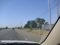
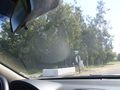
Route 43! We're going the right way. :)
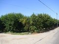
Fruit trees near the hash.
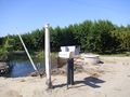
Peculiar mailbox of the house by the hash.
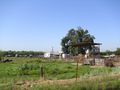
Hashpoint is in sight. It's in the heap of crap to the left at the far back.
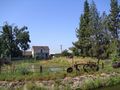
The house next to the hashpoint.
Quick 'n dirty picture of the street sign to prove we were at the right place.


