Difference between revisions of "2010-08-01 -38 144"
imported>Jiml m (Adjust result codes since no expedition when coordinates were known) |
imported>FippeBot m (Location) |
||
| Line 28: | Line 28: | ||
[[Category:Expedition planning]] | [[Category:Expedition planning]] | ||
| + | {{location|AU|VIC}} | ||
Revision as of 03:04, 9 August 2019
| Sun 1 Aug 2010 in -38,144: -38.2756420, 144.4991637 geohashing.info google osm bing/os kml crox |
Déjà vu aquatic geohash!
I (Stevage) visited this point about 6 months ago. Miraculously, I have both GPS and photographic proof.
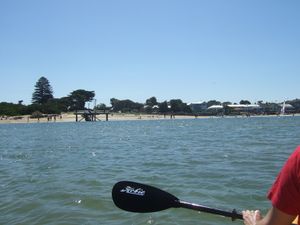
Ellen and I were visiting my friend James in Barwon Heads a couple of days after Christmas in 2009. We took our bikes on the train down to Geelong, then rode out along the rail trail towards Queenscliff, eventually turning south through Ocean Grove, then into Barwon Heads over the bridge. The next day, we went canoeing with James' dad, which is how we came close to the point.
It was a gorgeous day, the sun was shining, and a million people were out in the water. The Barwon River is pretty shallow there. At one point we paddled out under the bridge towards the ocean, only finding out afterwards that it's apparently dangerous.
In the photo above, the point is somewhere off to the right (forward is the western bank of the river). The time stamp on the photo is messed up as that camera always loses its time settings.
Achievements
(Note, I'm probably not going to revisit the hash - I find that an odd requirement of this achievement)
Is it true that Stevage earned the Déjà-vu geohash achievement?
|
