Difference between revisions of "2010-11-14 51 12"
From Geohashing
imported>TheOneRing (→TheOneRing) |
imported>TheOneRing (→Photos) |
||
| Line 21: | Line 21: | ||
Image:20101114Klebzig.jpg|The village of Klepzip (S direction) | Image:20101114Klebzig.jpg|The village of Klepzip (S direction) | ||
Image:20101114Zwebendorf.jpg|The village of Zwebendorf (N direction) | Image:20101114Zwebendorf.jpg|The village of Zwebendorf (N direction) | ||
| − | Image:20101114PowerPole.jpg|A power pole (W direction), a little bit left of it, was the hashpoint | + | Image:20101114PowerPole.jpg|A power pole (W direction), a little bit left of it, there was the hashpoint |
</gallery> | </gallery> | ||
Revision as of 09:31, 16 November 2010
| Sun 14 Nov 2010 in 51,12: 51.4891851, 12.1125707 geohashing.info google osm bing/os kml crox |
The Place
14 km East of Halle (Saale)
Who Went
- TheOneRing - by bike.
Expedition
TheOneRing
I was for the weekend at my parents' home and the hashpoint was really nearby, so I decided to make a small bicycle tour. There were no obstacles on my way, but comparing the coordinates afterwards I figured out that I missed the hashpoint by approx. 104 m.
Photos
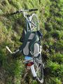
My bike
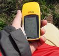
GPS reciever (obviously with the wrong coordinates)
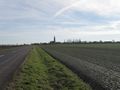
The village of Klepzip (S direction)
The village of Zwebendorf (N direction)
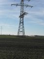
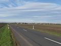
A power pole (W direction), a little bit left of it, there was the hashpoint


