Difference between revisions of "2010-11-21 46 7"
From Geohashing
imported>TheOneRing (→Photos) |
|||
| Line 16: | Line 16: | ||
== Photos == | == Photos == | ||
| + | <gallery perrow="4"> | ||
| + | Image:20101121Bike.jpg|My bike | ||
| + | Image:20101121StupidGrin.jpg|Stupid Grin after reaching the hashpoint | ||
| + | Image:20101121GPS.jpg|The proof that I reched the coordinates this time | ||
| + | Image:20101121Hashpoint.jpg|The tripod marks the today's hashpoint | ||
| + | </gallery> | ||
Revision as of 13:27, 21 November 2010
| Sun 21 Nov 2010 in 46,7: 46.9714152, 7.3468424 geohashing.info google osm bing/os kml crox |
The Place
The hashpoint is near the raod between Wohlen and Illiswil, approx. 5 km outside Berne in Western direction.
Whoe Went
TheOneRing - by bike.
Expedition
TheOneRing
The hashpoint was really nearby, so I decided to go by bike after lunch time. Unfortunately the weather was cloudy and a little foggy, therefore the countryside was not as attractive as usual.
Photos
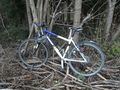
My bike

Stupid Grin after reaching the hashpoint
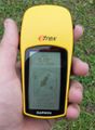
The proof that I reched the coordinates this time
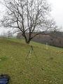
The tripod marks the today's hashpoint


