Difference between revisions of "2011-01-26 45 -123"
From Geohashing
imported>Jiml (Add Photos) |
imported>FippeBot m (Location) |
||
| Line 49: | Line 49: | ||
[[Category:Coordinates not reached]] | [[Category:Coordinates not reached]] | ||
[[Category:Not reached - No public access]] | [[Category:Not reached - No public access]] | ||
| + | {{location|US|OR|WI}} | ||
Latest revision as of 05:20, 9 August 2019
| Wed 26 Jan 2011 in 45,-123: 45.4680470, -123.0523932 geohashing.info google osm bing/os kml crox |
Location
A few hundred feet off Iowa Hill Road, in a field, near Cornelius, Oregon.
Participants
Plans
Jim may try to stop by over lunchtime, so it won't be dark.
Expedition
In the morning, I noticed how close the hashpoint was. I sent off a note to the local geohashing folks, but no one was interested in joining me, so I swung by around lunch time. I was pretty sure that I knew the neighbor of the hashpoint, and when I got there, I found that I did. (We get strawberries and blueberries from them.)
However, I didn't know the owner of the hayfield where the hashpoint was, and there was a No Trespassing sign on the driveway in, so I gave up and trying to get access.
Photos
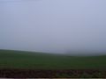
The area around the hashpoint
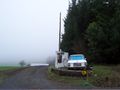
The driveway of the owners


Achievements
- No Trespassing