Difference between revisions of "2011-04-02 40 -104"
From Geohashing
imported>AkiTensai (→Participants) |
imported>FippeBot m (Location) |
||
| (9 intermediate revisions by 2 users not shown) | |||
| Line 8: | Line 8: | ||
And DON'T FORGET to add your expedition and the best photo you took to the gallery on the Main Page! We'd love to read your report, but that means we first have to discover it! | And DON'T FORGET to add your expedition and the best photo you took to the gallery on the Main Page! We'd love to read your report, but that means we first have to discover it! | ||
--> | --> | ||
| + | |||
{{meetup graticule | {{meetup graticule | ||
| lat=40 | | lat=40 | ||
| Line 14: | Line 15: | ||
}} | }} | ||
| − | |||
__NOTOC__ | __NOTOC__ | ||
== Location == | == Location == | ||
| − | |||
Near Co Rd 19 and Co Rd 38, about 5 miles from I-25 | Near Co Rd 19 and Co Rd 38, about 5 miles from I-25 | ||
== Participants == | == Participants == | ||
| − | + | *[[User:AkiTensai|AkiTensai]] | |
| − | *[[User:AkiTensai|AkiTensai]] | + | *JediMaster |
| + | *[[User:Stringgeek|Stringgeek]] | ||
== Plans == | == Plans == | ||
| − | + | As the spot is 1000 ft off of a paved road, not much in the way of plans needed. | |
== Expedition == | == Expedition == | ||
| − | + | The trip by pickup was as uneventful as the trip back. [[User:AkiTensai|AkiTensai]] failed a diplomacy roll for permission to get onto the property. We camped the road from 3:45p to 4:05p waiting to see if anyone else might show. Got bored and went to see a movie. Got pictures towards the Geohash from about 1000 ft away. | |
| − | |||
| − | |||
| − | |||
== Photos == | == Photos == | ||
| − | |||
| − | |||
| − | |||
<gallery perrow="5"> | <gallery perrow="5"> | ||
| + | Image:2011-04-02 40 -104 GPS.jpg | GPS w/Date | ||
| + | Image:2011-04-02_40_-104_So_Close_So_Far.jpg | So close, yet so far. | ||
| + | Image:2011-04-02_40_-104_Jedi.jpg | Jedi was just happy to be there. | ||
| + | Image:2011-04-02_40_-104_AkiNavigating.jpg | Jedi overwatching Aki navigate for JediMaster. | ||
</gallery> | </gallery> | ||
== Achievements == | == Achievements == | ||
{{#vardefine:ribbonwidth|800px}} | {{#vardefine:ribbonwidth|800px}} | ||
| − | + | {{No trespassing | |
| + | | latitude = 40 | ||
| + | | longitude = -104 | ||
| + | | date = 2011-04-02 | ||
| + | | name = [[User:AkiTensai|AkiTensai]], JediMaster, and [[User:Stringgeek|Stringgeek]] | ||
| + | | image = 2011-04-02 40 -104 So Close So Far.jpg | ||
| + | }} | ||
| − | |||
| − | |||
| − | |||
| − | |||
| − | |||
| − | |||
| − | |||
| − | |||
| − | |||
| − | |||
[[Category:Expeditions]] | [[Category:Expeditions]] | ||
| − | - | + | [[Category:Coordinates not reached]] |
| + | [[Category:Not reached - No public access]] | ||
[[Category:Expeditions with photos]] | [[Category:Expeditions with photos]] | ||
| − | + | {{location|US|CO|WE}} | |
| − | |||
| − | |||
| − | |||
| − | |||
| − | |||
| − | |||
| − | |||
| − | |||
| − | |||
| − | |||
| − | |||
| − | |||
| − | |||
| − | |||
| − | |||
Latest revision as of 03:55, 6 August 2019
| Sat 2 Apr 2011 in 40,-104: 40.2684066, -104.8820211 geohashing.info google osm bing/os kml crox |
Location
Near Co Rd 19 and Co Rd 38, about 5 miles from I-25
Participants
- AkiTensai
- JediMaster
- Stringgeek
Plans
As the spot is 1000 ft off of a paved road, not much in the way of plans needed.
Expedition
The trip by pickup was as uneventful as the trip back. AkiTensai failed a diplomacy roll for permission to get onto the property. We camped the road from 3:45p to 4:05p waiting to see if anyone else might show. Got bored and went to see a movie. Got pictures towards the Geohash from about 1000 ft away.
Photos
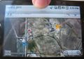
GPS w/Date
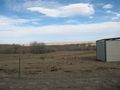
So close, yet so far.
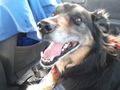
Jedi was just happy to be there.
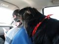
Jedi overwatching Aki navigate for JediMaster.


Achievements
AkiTensai, JediMaster, and Stringgeek earned the No trespassing consolation prize
|