Difference between revisions of "2011-04-29 37 -76"
From Geohashing
imported>Bob0the0mighty m ([live picture] Success again finally. Also upside down [http://www.openstreetmap.org/?lat=37.0533&lon=-76.3974&zoom=16&layers=B000FTF @37.0533,-76.3974]) |
imported>Bob0the0mighty m ([live] Made it to a point for the first time in over a year. Glad it was so close. Anyone else active in the area?) |
||
| Line 29: | Line 29: | ||
<!-- how it all turned out. your narrative goes here. --> | <!-- how it all turned out. your narrative goes here. --> | ||
| + | |||
| + | *Made it to a point for the first time in over a year. Glad it was so close. Anyone else active in the area? -- [[User:Bob0the0mighty|Bob0the0mighty]] [http://www.openstreetmap.org/?lat=37.05363958&lon=-76.39721362&zoom=16&layers=B000FTF @37.0536,-76.3972] 19:36, 29 April 2011 (EDT) | ||
== Tracklog == | == Tracklog == | ||
<!-- if your GPS device keeps a log, you may post a link here --> | <!-- if your GPS device keeps a log, you may post a link here --> | ||
Revision as of 23:37, 29 April 2011
| Fri 29 Apr 2011 in 37,-76: 37.0532816, -76.3973845 geohashing.info google osm bing/os kml crox |
Location
Participants
Plans
Expedition
- Made it to a point for the first time in over a year. Glad it was so close. Anyone else active in the area? -- Bob0the0mighty @37.0536,-76.3972 19:36, 29 April 2011 (EDT)
Tracklog
Photos
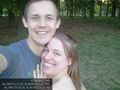
Success again finally. Also upside down @37.0533,-76.3974

Achievements