Difference between revisions of "2011-05-27 46 -92"
imported>Benjw m (→Photos: fix gallery) |
imported>GeorgDerReisende |
||
| Line 1: | Line 1: | ||
| − | |||
| − | |||
| − | |||
| − | |||
| − | |||
| − | |||
| − | |||
| − | |||
| − | |||
{{meetup graticule | {{meetup graticule | ||
| lat=46 | | lat=46 | ||
| Line 58: | Line 49: | ||
}} | }} | ||
| − | |||
| − | |||
| − | |||
| − | |||
| − | |||
| − | + | [[Category:Expeditions]] | |
| − | |||
| − | |||
| − | |||
| − | |||
[[Category:Expeditions with photos]] | [[Category:Expeditions with photos]] | ||
| − | |||
| − | |||
| − | |||
| − | |||
| − | |||
| − | |||
| − | |||
| − | |||
| − | |||
| − | |||
| − | |||
| − | |||
| − | |||
| − | |||
| − | |||
[[Category:Coordinates not reached]] | [[Category:Coordinates not reached]] | ||
[[Category:Not reached - No public access]] | [[Category:Not reached - No public access]] | ||
Revision as of 20:31, 14 November 2014
| Fri 27 May 2011 in Duluth: 46.1442566, -92.6768601 geohashing.info google osm bing/os kml crox |
Location
In some swampy woods on private property near Duxbury, MN.
Participants
Le Fou solo expedition.
Plans
Wait for the fateful day, see where the pin lands, hop in the stealth beetle and drive. Seeing the pin, I wonder if this is private property. There is a general store nearby (Duxbury Store), which also has a restaurant, so I'll stop in and ask there. Otherwise it looks to be about 50m from a dirt road/path that is only visible from satellite imagery. How bad can it be?
Expedition
A few minutes researching the maps looked promising. The weather was bright and sunny, breezy and still cool for almost June. Grabbed my hat, my root beer and hit the road, neatly avoiding road construction and the freeway. Discovered many dirt roads on the way, and the meaning of the large orange flags at the side of the road (very soft roadbed... recently reconstructed from being washed out)!
The road to the site was posted with the warning of minimal maintenance, really little more than some worn tire tracks through a swamp, mostly above water even given the wet spring weather lately. I was only nervous for my beetle making it through one stretch, but that's what adventures are for. The actual site turned out to be on private property with freshly posted "criminal trespassing" signs. I drove a bit further down the road to look for an area wide enough to turn around and saw an ancient abandoned car carcass. My phone's GPS was not as helpful as I'd hoped. I discovered where I could take three steps and travel from N46°8'17" to N46°8'9". This put me within the right latitude, but the longitude alas was deep inside the no trespassing zone.
It was a nice drive and trial run. Next time I will see about bringing a traveling companion, and may shoot for a meetup day. I may be able to load some kind of way point into my phone for more accurate on-site navigation to the coordinates. I'm not certain how dependable this will be without cell tower reception, so we shall see.
Photos
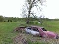
Abandoned Buick near the waypoint, probably of the last geohasher who ignored the no trespassing.

Needs a haiku.


Achievements
Le Fou earned the No trespassing consolation prize
|