Difference between revisions of "2011-05-30 39 -77"
From Geohashing
imported>TravisLow (→Location) |
imported>TravisLow (→Photos) |
||
| Line 41: | Line 41: | ||
--> | --> | ||
<gallery perrow="5"> | <gallery perrow="5"> | ||
| + | Image:2011-05-30 39 -77 A rock.jpg | The exact hashpoint, near as we could figure. It was the middle of a cornfield lying fallow. | ||
| + | Image:2011-05-30 39 -77 A rock with foot.jpg | Rock with daughter's foot. | ||
| + | Image:2011-05-30 39 -77 A rock with daughter.jpg | Rock with the entire daughter. | ||
| + | Image:2011-05-30 39 -77 Old house.jpg | Old farm house with tin roof, probably abandoned (we didn't check) | ||
| + | Image:2011-05-30 39 -77 spring house.jpg|A spring house! Wow! Haven't seen one of those in years. | ||
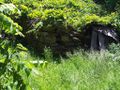
| + | Image:2011-05-30 39 -77 spring house closer.jpg|Closer view of spring house. We would have gone inside, but it had collapsed | ||
</gallery> | </gallery> | ||
Revision as of 21:40, 30 May 2011
| Mon 30 May 2011 in Frederick, Maryland: 39.1178768, -77.6393012 geohashing.info google osm bing/os kml crox |
Location
Between 12 and 1pm -- Midway between Leesburg and Purcellville, on State Route 77.
Participants
Plans
Between 12 and 1pm -- Midway between Leesburg and Purcellville, on State Route 77.
Expedition
Tracklog
Photos
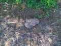
The exact hashpoint, near as we could figure. It was the middle of a cornfield lying fallow.
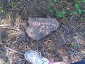
Rock with daughter's foot.

Rock with the entire daughter.
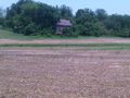
Old farm house with tin roof, probably abandoned (we didn't check)
A spring house! Wow! Haven't seen one of those in years.
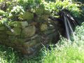
Closer view of spring house. We would have gone inside, but it had collapsed


Achievements