Difference between revisions of "2011-06-10 45 -121"
imported>Kydlt (Created page with "Here I go again, messing with the wiki. I was beginning to think that I might be getting how to do it, but then took a couple weeks off and now I don't remember anything. So, I...") |
imported>FippeBot m (Location) |
||
| (11 intermediate revisions by 2 users not shown) | |||
| Line 1: | Line 1: | ||
| − | + | <!-- If you did not specify these parameters in the template, please substitute appropriate values for IMAGE, LAT, LON, and DATE (YYYY-MM-DD format) | |
| − | + | [[Image:{{{image|IMAGE}}}|thumb|left]] | |
| − | + | Remove this section if you don't want an image at the top (left) of your report. You should remove the "Image:" or "File:" | |
| + | tag from your image file name, and replace the all upper-case word IMAGE in the above line. | ||
| + | |||
| + | And DON'T FORGET to add your expedition and the best photo you took to the gallery on the Main Page! We'd love to read your report, but that means we first have to discover it! | ||
| + | --> | ||
| + | {{meetup graticule | ||
| + | | lat=45 | ||
| + | | lon=-121 | ||
| + | | date=2011-06-10 | ||
| + | }} | ||
| + | |||
| + | |||
| + | __NOTOC__ | ||
| + | == Location == | ||
| + | <!-- where you've surveyed the hash to be --> | ||
| + | Today's spot is about 2 1/4 mi walk, up about 2400 ft from the end of Herman Creek Rd in Cascade Locks, OR | ||
| + | |||
| + | == Participants == | ||
| + | |||
| + | * [[User:Kydlt|kydlt]] | ||
| + | |||
| + | == Plans == | ||
| + | |||
| + | My topo map shows a trail most of the way there. And a road that goes up to a trailhead only about 2 1/2 miles from the hash. The cross-country leg looks to be less than 1000 ft on a traverse, so (famous last words) a pretty easy crossing. Looks to be woods. | ||
| + | |||
| + | == Expedition == | ||
| + | |||
| + | Thwarted. | ||
| + | |||
| + | The road to the trailhead was gated, parking there and walking in would have added another mile, I guessed. I drove around and found a different trailhead that would have taken me up trail 406 Herman Creek Trail and would have added a little more walking, but it needed a parking permit, and that was in the other car. | ||
| + | |||
| + | But I walked up the trail a little ways anyway, tempting the wilderness parking police as much as I dared, | ||
| + | then went to Cascade Locks and walked around the park. | ||
| + | |||
| + | == Photos == | ||
| + | |||
| + | <gallery perrow="5"> | ||
| + | Image:2011-06-10 45 -121 BotG.jpg | Most expeditions start at this most excellent crossing. | ||
| + | Image:2011-06-10 45 -121 need a glove.jpg | I went up far enough to know that I did find the right place. | ||
| + | Image:2011-06-10 45 -121 locals.jpg | Other people were here before us. There is only so much that can be done with a pocket camera. | ||
| + | Image:2011-06-10 45 -121 BotG profile.jpg | From the WA side. Technically it's a cantilever through truss. | ||
| + | </gallery> | ||
| + | |||
| + | == Achievements == | ||
| + | {{#vardefine:ribbonwidth|800px}} | ||
| + | |||
| + | * No Trespassing (without a permit...) | ||
| + | |||
| + | |||
| + | [[Category:Expeditions]] | ||
| + | |||
| + | [[Category:Expeditions with photos]] | ||
| + | |||
| + | [[Category:Coordinates not reached]] | ||
| + | [[Category:Not reached - No public access]] | ||
| + | {{location|US|OR|HO}} | ||
Latest revision as of 06:47, 9 August 2019
| Fri 10 Jun 2011 in 45,-121: 45.6593365, -121.8061133 geohashing.info google osm bing/os kml crox |
Location
Today's spot is about 2 1/4 mi walk, up about 2400 ft from the end of Herman Creek Rd in Cascade Locks, OR
Participants
Plans
My topo map shows a trail most of the way there. And a road that goes up to a trailhead only about 2 1/2 miles from the hash. The cross-country leg looks to be less than 1000 ft on a traverse, so (famous last words) a pretty easy crossing. Looks to be woods.
Expedition
Thwarted.
The road to the trailhead was gated, parking there and walking in would have added another mile, I guessed. I drove around and found a different trailhead that would have taken me up trail 406 Herman Creek Trail and would have added a little more walking, but it needed a parking permit, and that was in the other car.
But I walked up the trail a little ways anyway, tempting the wilderness parking police as much as I dared, then went to Cascade Locks and walked around the park.
Photos
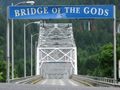
Most expeditions start at this most excellent crossing.
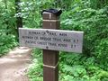
I went up far enough to know that I did find the right place.
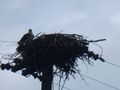
Other people were here before us. There is only so much that can be done with a pocket camera.
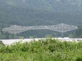
From the WA side. Technically it's a cantilever through truss.


Achievements
- No Trespassing (without a permit...)