Difference between revisions of "2011-07-19 50 11"
imported>Mampfred |
imported>Mampfred |
||
| Line 11: | Line 11: | ||
== Participants == | == Participants == | ||
*[[User:Mampfred|Mampfred]] | *[[User:Mampfred|Mampfred]] | ||
| − | *[[User:Rincewind|Rincewind]] | + | *[[User:Rincewind|Rincewind]] (chickened out) |
== Plans == | == Plans == | ||
| Line 17: | Line 17: | ||
== Expedition == | == Expedition == | ||
| − | + | Rincewind chickened out due to a bad back so I steyed at work a little longer and started around 8pm. I had carefully planned this as a 7km-walk-tron-land expedition and followed the plan exactly before arriving at a soaking wet field of some very very thick plant. | |
| + | |||
| + | I tried following some tractor tracks to get closer to the hash but made it up to about 23 meters at which point I would have had to stalk through the plants. Considering how wet the soil was (I had serious trouble walking even with my trekking shoes) and how thick the plants were I definitely would have destroyed some of them so I called it a day and headed back. | ||
== Tracklog == | == Tracklog == | ||
| − | + | See [http://www.everytrail.com/view_trip.php?trip_id=1197746 here]. | |
== Photos == | == Photos == | ||
| − | |||
| − | |||
| − | |||
<gallery perrow="5"> | <gallery perrow="5"> | ||
| + | Image:2011-07-19_50_11_grabsteine.jpg | Discount gravestones along the way. Maybe some other time. | ||
| + | Image:2011-07-19_50_11_tracks_between_fields.jpg | This could get me closer to the hash. Last chance. | ||
| + | Image:2011-07-19_50_11_hash.jpg | A look at the hash. | ||
| + | Image:2011-07-19_50_11_23_meters.jpg | Only 23 meters to the hash. Too much for this time though. | ||
| + | Image:2011-07-19_50_11_dirt.jpg | Proper shoes for hashing. They don't even look as dirty as it felt in the field ... | ||
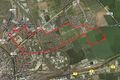
| + | Image:2011-07-19_50_11_plan.jpg | The plan for the tron achievement. | ||
| + | Image:2011-07-19_50_11_tracklog.jpg | The actual track log. Pretty close, ey? | ||
</gallery> | </gallery> | ||
== Achievements == | == Achievements == | ||
{{#vardefine:ribbonwidth|800px}} | {{#vardefine:ribbonwidth|800px}} | ||
| − | + | None. | |
| − | |||
| − | |||
| − | |||
| − | |||
[[Category:Expeditions]] | [[Category:Expeditions]] | ||
| − | |||
[[Category:Expeditions with photos]] | [[Category:Expeditions with photos]] | ||
| − | |||
| − | |||
| − | |||
| − | |||
| − | |||
| − | |||
| − | |||
| − | |||
| − | |||
[[Category:Coordinates not reached]] | [[Category:Coordinates not reached]] | ||
| − | + | [[Category:Not reached - No public access]] | |
| − | |||
| − | [[Category:Not reached - No public access]] | ||
| − | |||
| − | |||
| − | |||
Revision as of 07:30, 20 July 2011
| Tue 19 Jul 2011 in 50,11: 50.9844916, 11.0788194 geohashing.info google osm bing/os kml crox |
Location
Eeeeek. That's just 3,5km from where we work. On a field.
Participants
Plans
Go there after work. Probably around 6-pm-ish.
Expedition
Rincewind chickened out due to a bad back so I steyed at work a little longer and started around 8pm. I had carefully planned this as a 7km-walk-tron-land expedition and followed the plan exactly before arriving at a soaking wet field of some very very thick plant.
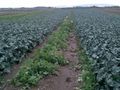
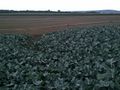
I tried following some tractor tracks to get closer to the hash but made it up to about 23 meters at which point I would have had to stalk through the plants. Considering how wet the soil was (I had serious trouble walking even with my trekking shoes) and how thick the plants were I definitely would have destroyed some of them so I called it a day and headed back.
Tracklog
See here.
Photos

Discount gravestones along the way. Maybe some other time.
This could get me closer to the hash. Last chance.
A look at the hash.

Only 23 meters to the hash. Too much for this time though.
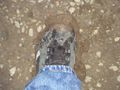
Proper shoes for hashing. They don't even look as dirty as it felt in the field ...
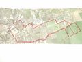
The plan for the tron achievement.
The actual track log. Pretty close, ey?


Achievements
None.