Difference between revisions of "2011-07-19 46 -117"
imported>Michael5000 m (→Expedition) |
imported>Michael5000 |
||
| Line 1: | Line 1: | ||
| − | |||
| − | |||
| − | |||
| − | |||
| − | |||
| − | |||
| − | |||
| − | |||
{{meetup graticule | {{meetup graticule | ||
| lat=46 | | lat=46 | ||
| Line 14: | Line 6: | ||
}} | }} | ||
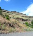
| − | [[File:2011-07-19 | + | [[File:2011-07-19 46 -117 Ridge.JPG|500 px]] |
| − | + | This is why we didn't try to hike in from the road. | |
__NOTOC__ | __NOTOC__ | ||
== Location == | == Location == | ||
| − | + | In a canyon west of Asotin, Washington. | |
== Participants == | == Participants == | ||
| Line 37: | Line 29: | ||
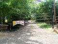
I was VERY puzzled. I triple-checked the coordinates I had fed the GPS. I checked to see if I had entered them in the wrong format. I hypothesized that there might be a parallel road running just across the ridge. But it was Mrs.5000 who had it right: a private ranch access that I hadn't even noticed on the way in turned out to be the road I had seen in the morning. It was gated and plastered with no-nonsense warnings. | I was VERY puzzled. I triple-checked the coordinates I had fed the GPS. I checked to see if I had entered them in the wrong format. I hypothesized that there might be a parallel road running just across the ridge. But it was Mrs.5000 who had it right: a private ranch access that I hadn't even noticed on the way in turned out to be the road I had seen in the morning. It was gated and plastered with no-nonsense warnings. | ||
| + | |||
| + | [[File:2011-07-19 46 -117 Gate.JPG|500 px]] | ||
D'oh. Points off for trusting Google Maps, but MAJOR points off for not even CHECKING Google Maps. | D'oh. Points off for trusting Google Maps, but MAJOR points off for not even CHECKING Google Maps. | ||
| Line 47: | Line 41: | ||
--> | --> | ||
<gallery perrow="5"> | <gallery perrow="5"> | ||
| + | File:2011-07-19 46 -117 Road.JPG | ||
| + | File:2011-07-19 46 -117 Ridge.JPG | ||
| + | File:2011-07-19 46 -117 Gate.JPG | ||
</gallery> | </gallery> | ||
| Line 54: | Line 51: | ||
| − | |||
| − | |||
[[Category:New report]] | [[Category:New report]] | ||
| − | |||
| − | |||
| − | |||
| − | |||
| − | |||
| − | |||
| − | |||
[[Category:Expeditions]] | [[Category:Expeditions]] | ||
| − | |||
[[Category:Expeditions with photos]] | [[Category:Expeditions with photos]] | ||
| − | |||
| − | |||
| − | |||
| − | |||
| − | |||
| − | |||
| − | |||
| − | |||
| − | |||
[[Category:Coordinates not reached]] | [[Category:Coordinates not reached]] | ||
| − | + | [[Category:Not reached - No public access]] | |
| − | |||
| − | [[Category:Not reached - No public access]] | ||
| − | |||
| − | |||
| − | |||
Revision as of 03:32, 20 July 2011
| Tue 19 Jul 2011 in 46,-117: 46.2848191, -117.3209582 geohashing.info google osm bing/os kml crox |

This is why we didn't try to hike in from the road.
Location
In a canyon west of Asotin, Washington.
Participants
Expedition
This was the first known attempt to hash the Pullman graticule.
I saw on Google Maps that the hashpoint was on a road and, like a fool, checked no further. We left curvy Washington State Highway 129 at Asotin and forged westward on the "only possible road" (as I believe I said) that would take us to the hashpoint. It was a lovely canyon road. And really, it dived towards the point like an arrow! For about a dozen miles! ... until we were about two miles out, when it began a sadistic loop south.
We got to within a mile and a half, but by then an enormous ridgeline blocked the way. We didn't give up! We continued on the "only possible road" as it kept curving to the right, as if it just might, just might, curve back on itself and head back towards the hashpoint. But eventually we got to a National Forest map posted by the side of the road that removed all doubt. The only possible road did not, and would not, reach the hashpoint.
I was VERY puzzled. I triple-checked the coordinates I had fed the GPS. I checked to see if I had entered them in the wrong format. I hypothesized that there might be a parallel road running just across the ridge. But it was Mrs.5000 who had it right: a private ranch access that I hadn't even noticed on the way in turned out to be the road I had seen in the morning. It was gated and plastered with no-nonsense warnings.

D'oh. Points off for trusting Google Maps, but MAJOR points off for not even CHECKING Google Maps.
Expedition Thwarted.
Photos
- 2011-07-19 46 -117 Road.JPG