Difference between revisions of "2012-01-20 59 17"
imported>Cjk ([retro picture] Marker in the snow.) |
imported>Cjk |
||
| Line 1: | Line 1: | ||
| − | |||
<!-- If you did not specify these parameters in the template, please substitute appropriate values for IMAGE, LAT, LON, and DATE (YYYY-MM-DD format) | <!-- If you did not specify these parameters in the template, please substitute appropriate values for IMAGE, LAT, LON, and DATE (YYYY-MM-DD format) | ||
| Line 19: | Line 18: | ||
== Location == | == Location == | ||
<!-- where you've surveyed the hash to be --> | <!-- where you've surveyed the hash to be --> | ||
| + | Underneath a cloud in google maps. | ||
| + | |||
| + | Actually in an alottment garden in Flemingsberg. | ||
== Participants == | == Participants == | ||
<!-- who attended --> | <!-- who attended --> | ||
| + | [[User:Cjk|Carl-Johan]] | ||
== Plans == | == Plans == | ||
<!-- what were the original plans --> | <!-- what were the original plans --> | ||
| + | Check out the driven route google maps [https://maps.google.com/maps?saddr=Unknown+road&daddr=59.212477849568,17.949532351249+to:59.2251414,17.940631+to:58.212477849568,14.949532351249+to:58.22327,14.9481+to:58.261201,14.960958+to:58.212477849568,13.949532351249+to:58.41773,13.46604+to:58.212477849568,12.949532351249+to:58.212477849568,11.949532351249+to:Gamla+Almedalsv%C3%A4gen,+G%C3%B6teborg,+Sverige&hl=en&ie=UTF8&ll=58.967004,14.72168&spn=2.764406,7.064209&sll=58.322472,13.927917&sspn=0.703866,1.766052&geocode=FaBViQMdPPYSAQ%3BFb6ChwMdXOMRAQ%3BFTW0hwMdl8ARASk_Ue4L4HBfRjGg8H0Y8_4AEw%3BFX5AeAMdnBzkAA%3BFaZqeAMdBBfkACmxoQVAyixaRjGhZ9QX8_4AEw%3BFdH-eAMdPknkACmRNKuwEdNbRjGwLtQX8_4AEw%3BFX5AeAMdXNrUAA%3BFUJiewMduHnNAClbsR387B9bRjFB3dMIeJABEw%3BFX5AeAMdHJjFAA%3BFX5AeAMd3FW2AA%3BFW08cAMd9Ri3ACmnXh_PovNPRjFVaq2VXx8y7g&vpsrc=6&mra=dvme&mrsp=7&sz=9&via=2,4,5,7&t=h&z=7 here]! | ||
| + | Since I was going down to Onsala for my mom's 65th birthday anyway this weekend, why not try to get some [[Virgin Graticule|virgin graticules]] on the way down. And what do you know, 5 of them lined up next to great roads like E4, 26, 193, 46, 47, E20 and E6. This time, going East-West was going to be easy. And three of them were virgins! Time to deflower. | ||
| + | |||
| + | *[[2012-01-20 59 17]] | ||
| + | *[[2012-01-20 58 14]] Virgin [[Tranås, Sweden]] | ||
| + | *[[2012-01-20 58 13]] Virgin [[Skövde, Sweden]] | ||
| + | *[[2012-01-20 58 12]] | ||
| + | *[[2012-01-20 58 11]] Virgin [[Uddevalla, Sweden]] | ||
| + | |||
== Expedition == | == Expedition == | ||
<!-- how it all turned out. your narrative goes here. --> | <!-- how it all turned out. your narrative goes here. --> | ||
| + | I packed the car and fueled it up and tried to leave as early as I could. Had a very nice dinner the night before so was a bit tired. Five-O pulled over a car at the gas station so police achievement. Took Huddingeleden to Flemingsberg and continued past the courthouse until GPS said stop. Hopped out and walked behind the appartment buildings and it turns out the hash was in the middle of an alottment garden. Sky was all gray so bearings was hard and GPS in the phone was super slow to update, sometimes taking over a minute so the last meters were tough to pinpoint. | ||
| − | + | Found it inside someones little lot in front of a shed. Took a panorama and marked in the snow, froze a bit since it was -1 C so jogged back to the car. | |
| − | |||
| + | Onwards to [[2012-01-20 58 14]]! | ||
== Photos == | == Photos == | ||
<!-- Insert pictures between the gallery tags using the following format: | <!-- Insert pictures between the gallery tags using the following format: | ||
| Line 37: | Line 50: | ||
--> | --> | ||
<gallery perrow="5"> | <gallery perrow="5"> | ||
| − | |||
| − | |||
| − | |||
| − | |||
| − | |||
| − | |||
| − | |||
| − | |||
Image:2012-01-20_59_17_19-54-46-448.jpg | Start of MONSTER hash | Image:2012-01-20_59_17_19-54-46-448.jpg | Start of MONSTER hash | ||
| Line 55: | Line 60: | ||
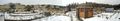
Image:2012-01-20_59_17_19-59-57-343.jpg | Allotment garden | Image:2012-01-20_59_17_19-59-57-343.jpg | Allotment garden | ||
| + | |||
| + | Image:2012-01-20_59_17_11-11-02-755.jpg | Nephew and I [http://www.openstreetmap.org/?lat=59.21256909&lon=17.94947533&zoom=16&layers=B000FTF @59.2126,17.9495] | ||
| + | |||
| + | Image:2012-01-20_59_17_11-11-29-603.jpg | It's cold [http://www.openstreetmap.org/?lat=59.21258313&lon=17.94934650&zoom=16&layers=B000FTF @59.2126,17.9493] | ||
| + | |||
| + | Image:2012-01-20_59_17_11-12-07-689.jpg | Panorama 1 [http://www.openstreetmap.org/?lat=59.21250765&lon=17.94935823&zoom=16&layers=B000FTF @59.2125,17.9494] | ||
| + | |||
| + | Image:2012-01-20_59_17_11-12-42-393.jpg | Panorama 2 [http://www.openstreetmap.org/?lat=59.21245514&lon=17.94957147&zoom=16&layers=B000FTF @59.2125,17.9496] | ||
Image:2012-01-20_59_17_20-03-05-959.jpg | Marker in the snow. | Image:2012-01-20_59_17_20-03-05-959.jpg | Marker in the snow. | ||
Revision as of 20:53, 21 January 2012
| Fri 20 Jan 2012 in 59,17: 59.2124778, 17.9495324 geohashing.info google osm bing/os kml crox |
Location
Underneath a cloud in google maps.
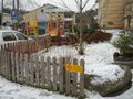
Actually in an alottment garden in Flemingsberg.
Participants
Plans
Check out the driven route google maps here!
Since I was going down to Onsala for my mom's 65th birthday anyway this weekend, why not try to get some virgin graticules on the way down. And what do you know, 5 of them lined up next to great roads like E4, 26, 193, 46, 47, E20 and E6. This time, going East-West was going to be easy. And three of them were virgins! Time to deflower.
- 2012-01-20 59 17
- 2012-01-20 58 14 Virgin Tranås, Sweden
- 2012-01-20 58 13 Virgin Skövde, Sweden
- 2012-01-20 58 12
- 2012-01-20 58 11 Virgin Uddevalla, Sweden
Expedition
I packed the car and fueled it up and tried to leave as early as I could. Had a very nice dinner the night before so was a bit tired. Five-O pulled over a car at the gas station so police achievement. Took Huddingeleden to Flemingsberg and continued past the courthouse until GPS said stop. Hopped out and walked behind the appartment buildings and it turns out the hash was in the middle of an alottment garden. Sky was all gray so bearings was hard and GPS in the phone was super slow to update, sometimes taking over a minute so the last meters were tough to pinpoint.
Found it inside someones little lot in front of a shed. Took a panorama and marked in the snow, froze a bit since it was -1 C so jogged back to the car.
Onwards to 2012-01-20 58 14!
Photos

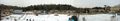
Start of MONSTER hash

Five-O
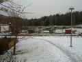
Playground
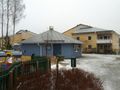
Buildings
Allotment garden

Nephew and I @59.2126,17.9495

It's cold @59.2126,17.9493
Panorama 1 @59.2125,17.9494
Panorama 2 @59.2125,17.9496
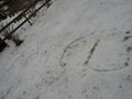
Marker in the snow.


Achievements