Difference between revisions of "Template:Expedition Images2/2012-02-04"
From Geohashing
imported>SDGathman (→Location) |
imported>SDGathman (→Tracklog) |
||
| Line 33: | Line 33: | ||
== Tracklog == | == Tracklog == | ||
<!-- if your GPS device keeps a log, you may post a link here --> | <!-- if your GPS device keeps a log, you may post a link here --> | ||
| + | http://www.openstreetmap.org/user/SDGathman/traces/1176133 | ||
== Photos == | == Photos == | ||
Revision as of 03:25, 5 February 2012
| Sat 4 Feb 2012 in 38,-77: 38.8079377, -77.5303929 geohashing.info google osm bing/os kml crox |
Location
Part of Manassas battlefield park, just across a creek from a handy park road. Park open to the public until dark. I could go again if anyone wants to go on Sunday. I forgot my camera, and had to use my cell phone.
Participants
Plans
Expedition
Tracklog
http://www.openstreetmap.org/user/SDGathman/traces/1176133
Photos
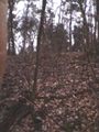
The meetup location on a wooded hillside
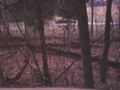
Across a creek from the park road.


Achievements