Difference between revisions of "2004-11-12 59 18"
From Geohashing
imported>Cjk |
imported>FippeBot m (Location) |
||
| (3 intermediate revisions by one other user not shown) | |||
| Line 53: | Line 53: | ||
When I reached the top of the hill I found the tree that was the hash but the hash was getting confused by the clouds and buildings but according to Google maps I was right on the spot. Took some pics and continued to the next one. | When I reached the top of the hill I found the tree that was the hash but the hash was getting confused by the clouds and buildings but according to Google maps I was right on the spot. Took some pics and continued to the next one. | ||
| + | |||
| + | [[Image:2004-11-12_59_18_14-39-33-765.jpg]] | ||
== Photos == | == Photos == | ||
| Line 82: | Line 84: | ||
<!-- =============== USEFUL CATEGORIES FOLLOW ================ | <!-- =============== USEFUL CATEGORIES FOLLOW ================ | ||
Delete the next line ONLY if you have chosen the appropriate categories below. If you are unsure, don't worry. People will read your report and help you with the classification. --> | Delete the next line ONLY if you have chosen the appropriate categories below. If you are unsure, don't worry. People will read your report and help you with the classification. --> | ||
| − | [[Category: | + | [[Category:Expeditions with photos]] |
| + | [[Category:Retro coordinates reached]] | ||
| + | |||
<!-- Potential categories. Please include all the ones appropriate to your expedition --> | <!-- Potential categories. Please include all the ones appropriate to your expedition --> | ||
| Line 109: | Line 113: | ||
[[Category:Not reached - Did not attempt]] when you went to an alternate location, or decided early on to abort the expedition. | [[Category:Not reached - Did not attempt]] when you went to an alternate location, or decided early on to abort the expedition. | ||
--> | --> | ||
| + | {{location|SE|AB}} | ||
Latest revision as of 03:56, 7 August 2019
| Fri 12 Nov 2004 in 59,18: 59.3453552, 18.1007515 geohashing.info google osm bing/os kml crox |
Location
Right by a tree next to an apartment block near Gärdet.
Participants
Plans
To try out my new code for generating all Retro hashes around your position I decided to try as many as I could during three days.
First retro, day 1:
Day 2:
- 1929-05-19 59 18
- 1970-10-18 59 18
- 1931-11-17 59 18
- 1942-10-23 59 18
- 1987-05-03 59 18
- 1952-04-14 59 18
- 1953-02-26 59 18
Day 3:
Retro Expedition 2012-02-09
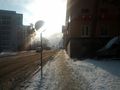
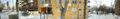
I continued from the last retro up the street and up a hill. Some pics along the way. This retro stuff is a good way to really learn your city.
When I reached the top of the hill I found the tree that was the hash but the hash was getting confused by the clouds and buildings but according to Google maps I was right on the spot. Took some pics and continued to the next one.

Photos
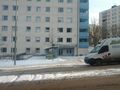
Student housing en route
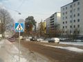
Looking north
Looking south
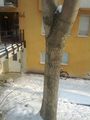
Hash in tree
Panorama of tree
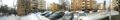
Panorama of road


