Difference between revisions of "2012-02-18 -7 112"
imported>Comepradz (→Location) |
imported>FippeBot m (Location) |
||
| (9 intermediate revisions by 3 users not shown) | |||
| Line 1: | Line 1: | ||
| − | |||
<!-- If you did not specify these parameters in the template, please substitute appropriate values for IMAGE, LAT, LON, and DATE (YYYY-MM-DD format) | <!-- If you did not specify these parameters in the template, please substitute appropriate values for IMAGE, LAT, LON, and DATE (YYYY-MM-DD format) | ||
| Line 15: | Line 14: | ||
}} | }} | ||
| − | + | ||
__NOTOC__ | __NOTOC__ | ||
== Location == | == Location == | ||
| − | + | ||
At Tropodo 1 St. Waru - Sidoarjo, Near Juanda International Airport. | At Tropodo 1 St. Waru - Sidoarjo, Near Juanda International Airport. | ||
== Participants == | == Participants == | ||
| − | + | ||
| + | * [[User:Comepradz|Yoppy Halilintar]] | ||
== Plans == | == Plans == | ||
<!-- what were the original plans --> | <!-- what were the original plans --> | ||
| + | Weekend, I checked today's hash via my droid and surprised because it falls just about 2.95 km from my house. So I decided to have a 4 pm meet up with any other geohasher. | ||
== Expedition == | == Expedition == | ||
| − | + | ||
| + | So it was my first expedition. I woke up this afternoon and prepared my ride. | ||
| + | I know exactly where the hash is because I used to have a ride around there like 3 years ago. | ||
| + | |||
| + | It was a fast ride, just under 30 minutes, compared to usual traffic jam I had in Surabaya. | ||
| + | I didn't have any idea that the hashpoint was inside a house. Someone approached and asked | ||
| + | me. I said I came from an adventure community. I asked permission to take few shot around | ||
| + | his house. Unfortunately I didn't got his shot because he went into his house. | ||
| + | |||
| + | I decided to get back to my house approximately 25 minutes later as I assumed no other | ||
| + | geohasher would showed up. | ||
== Tracklog == | == Tracklog == | ||
| Line 46: | Line 57: | ||
Image:2012-02-18_-7_112_16-48-38-750.jpg | Few meters to go.. | Image:2012-02-18_-7_112_16-48-38-750.jpg | Few meters to go.. | ||
| + | |||
| + | Image:2012-02-18_-7_112_16-58-15-516.jpg | Have to recheck the coordinate.. | ||
</gallery> | </gallery> | ||
| Line 52: | Line 65: | ||
<!-- Add any achievement ribbons you earned below, or remove this section --> | <!-- Add any achievement ribbons you earned below, or remove this section --> | ||
| + | <!-- {{land geohash | latitude = -7 | longitude = 112 | date = 2012-02-18 | name = Yoppy Halilintar }} | ||
| + | {{Virgin graticule | latitude = -7 | longitude = 112 | date = 2012-02-18 | name = Yoppy Halilintar }} | ||
| + | This ribbon requires that you actually reach the hashpoint --> | ||
| + | |||
| + | {{No trespassing | latitude = -7 | longitude = 112 | date = 2012-02-18 | name = Yoppy Halilintar }} | ||
| − | |||
| − | |||
| − | |||
| − | |||
| − | |||
| − | |||
| − | |||
| − | |||
[[Category:Expeditions]] | [[Category:Expeditions]] | ||
| − | + | ||
[[Category:Expeditions with photos]] | [[Category:Expeditions with photos]] | ||
| − | + | ||
| + | <!-- | ||
| + | Don't know if this one applies here | ||
| + | |||
[[Category:Expedition without GPS]] | [[Category:Expedition without GPS]] | ||
--> | --> | ||
| − | |||
| − | |||
| − | |||
| − | |||
| − | + | ||
[[Category:Coordinates not reached]] | [[Category:Coordinates not reached]] | ||
| − | + | ||
| − | + | ||
| − | [[Category:Not reached - No public access]] | + | [[Category:Not reached - No public access]] |
| − | + | {{location|ID|JW|JI}} | |
| − | |||
| − | |||
Latest revision as of 02:26, 13 August 2019
| Sat 18 Feb 2012 in -7,112: -7.3629672, 112.7616397 geohashing.info google osm bing/os kml crox |
Location
At Tropodo 1 St. Waru - Sidoarjo, Near Juanda International Airport.
Participants
Plans
Weekend, I checked today's hash via my droid and surprised because it falls just about 2.95 km from my house. So I decided to have a 4 pm meet up with any other geohasher.
Expedition
So it was my first expedition. I woke up this afternoon and prepared my ride. I know exactly where the hash is because I used to have a ride around there like 3 years ago.
It was a fast ride, just under 30 minutes, compared to usual traffic jam I had in Surabaya. I didn't have any idea that the hashpoint was inside a house. Someone approached and asked me. I said I came from an adventure community. I asked permission to take few shot around his house. Unfortunately I didn't got his shot because he went into his house.
I decided to get back to my house approximately 25 minutes later as I assumed no other geohasher would showed up.
Tracklog
Photos

A smile actually, not a grin :D @-7.3632,112.7620
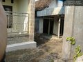
If I'm not mistaken, the spot must be inside that house. @-7.3632,112.7620
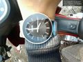
4 pm, nobody but me @-7.3632,112.7620
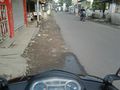
Few meters to go..
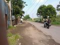
Have to recheck the coordinate..


Achievements
Yoppy Halilintar earned the No trespassing consolation prize
|