Difference between revisions of "2012-03-08 19 -155"
imported>Simonradford (→Photos) |
imported>Jiml m (Add ribbon indicators) |
||
| Line 14: | Line 14: | ||
}} | }} | ||
| − | + | ||
__NOTOC__ | __NOTOC__ | ||
== Location == | == Location == | ||
| − | + | ||
In a cattle pasture just outside Volcanoes National Park. Only a mile or so from the highway. | In a cattle pasture just outside Volcanoes National Park. Only a mile or so from the highway. | ||
== Participants == | == Participants == | ||
| − | + | ||
| − | [[User:Simonradford|Simon]] | + | * [[User:Simonradford|Simon]] |
== Plans == | == Plans == | ||
| − | + | ||
No plans. Spontaneity rules. | No plans. Spontaneity rules. | ||
== Expedition == | == Expedition == | ||
| − | + | ||
At 5 pm I decided to try. Sunset was 6:30 pm. Google said the hash was 35 miles away and only a mile or so from the highway. Seemed doable. | At 5 pm I decided to try. Sunset was 6:30 pm. Google said the hash was 35 miles away and only a mile or so from the highway. Seemed doable. | ||
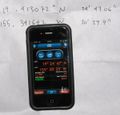
Drove up past Volcano through the usual east Hawaii drizzle. A couple of miles past the crest, it dried out and I found a little dirt road leading off through an old a'a field. The road has a locked gate but no signs. There's a convenient parking pullout a few feet away. A nice sunset stroll down the dirt road led to some cattle pastures. Flushed some nene. Followed the GPS through the pastures until I was stopped by a fence, electrified. Only 5 arcsec away! Close, but not close enough to claim success. By that time, it was almost completely dark, so I threw in the towel. Walked back to the car by the light of Venus and Jupiter with the Stygian glow of Kilauea's smoke column close by. | Drove up past Volcano through the usual east Hawaii drizzle. A couple of miles past the crest, it dried out and I found a little dirt road leading off through an old a'a field. The road has a locked gate but no signs. There's a convenient parking pullout a few feet away. A nice sunset stroll down the dirt road led to some cattle pastures. Flushed some nene. Followed the GPS through the pastures until I was stopped by a fence, electrified. Only 5 arcsec away! Close, but not close enough to claim success. By that time, it was almost completely dark, so I threw in the towel. Walked back to the car by the light of Venus and Jupiter with the Stygian glow of Kilauea's smoke column close by. | ||
| − | == | + | == Photos == |
| − | |||
| − | |||
| − | |||
| − | |||
<gallery perrow="5"> | <gallery perrow="5"> | ||
Image:2012-03-08_19_-155-a.jpg | Almost got there. Only 5 arcsec away. | Image:2012-03-08_19_-155-a.jpg | Almost got there. Only 5 arcsec away. | ||
| Line 50: | Line 46: | ||
== Achievements == | == Achievements == | ||
{{#vardefine:ribbonwidth|800px}} | {{#vardefine:ribbonwidth|800px}} | ||
| − | + | ||
| + | * No trespassing | ||
[[Category:Expeditions]] | [[Category:Expeditions]] | ||
| Line 56: | Line 53: | ||
[[Category:Coordinates not reached]] | [[Category:Coordinates not reached]] | ||
[[Category:Not reached - No public access]] | [[Category:Not reached - No public access]] | ||
| − | |||
| − | |||
| − | |||
| − | |||
| − | |||
| − | |||
| − | |||
| − | |||
| − | |||
| − | |||
| − | |||
| − | |||
| − | |||
| − | |||
| − | |||
| − | |||
| − | |||
| − | |||
| − | |||
| − | |||
| − | |||
| − | |||
| − | |||
| − | |||
| − | |||
| − | |||
| − | |||
| − | |||
| − | |||
| − | |||
| − | |||
Revision as of 14:21, 13 June 2013
| Thu 8 Mar 2012 in 19,-155: 19.4130725, -155.3416416 geohashing.info google osm bing/os kml crox |
Location
In a cattle pasture just outside Volcanoes National Park. Only a mile or so from the highway.
Participants
Plans
No plans. Spontaneity rules.
Expedition
At 5 pm I decided to try. Sunset was 6:30 pm. Google said the hash was 35 miles away and only a mile or so from the highway. Seemed doable.
Drove up past Volcano through the usual east Hawaii drizzle. A couple of miles past the crest, it dried out and I found a little dirt road leading off through an old a'a field. The road has a locked gate but no signs. There's a convenient parking pullout a few feet away. A nice sunset stroll down the dirt road led to some cattle pastures. Flushed some nene. Followed the GPS through the pastures until I was stopped by a fence, electrified. Only 5 arcsec away! Close, but not close enough to claim success. By that time, it was almost completely dark, so I threw in the towel. Walked back to the car by the light of Venus and Jupiter with the Stygian glow of Kilauea's smoke column close by.
Photos
Achievements
- No trespassing


