Difference between revisions of "2012-03-15 53 -2"
From Geohashing
imported>Angel m |
imported>FippeBot m (Location) |
||
| (2 intermediate revisions by 2 users not shown) | |||
| Line 1: | Line 1: | ||
| − | |||
| − | |||
| − | |||
| − | |||
| − | |||
| − | |||
| − | |||
| − | |||
| − | |||
{{meetup graticule | {{meetup graticule | ||
| lat=53 | | lat=53 | ||
| Line 14: | Line 5: | ||
}} | }} | ||
| − | |||
__NOTOC__ | __NOTOC__ | ||
== Location == | == Location == | ||
| Line 23: | Line 13: | ||
== Expedition == | == Expedition == | ||
| − | Dad was asked to travel to the location and take a picture; he doesn't have a GPS device, but the building is clearly visible on the | + | Dad was asked to travel to the location and take a picture; he doesn't have a GPS device, but the building is clearly visible on the google satellite view. He couldn't reach the exact spot, but could take a picture of it from the road, as well as a couple of others to prove he's at the right corner. I guess this counts as not-quite-reaches, as the actual coords (so far as I can tell) lie in the field, and that's not publicly accessible. |
== Photos == | == Photos == | ||
| Line 43: | Line 33: | ||
}} | }} | ||
| − | + | ||
[[Category:Expeditions]] | [[Category:Expeditions]] | ||
| Line 49: | Line 39: | ||
[[Category:Expedition without GPS]] | [[Category:Expedition without GPS]] | ||
| − | [[Category:Not reached - No public access]] | + | [[Category:Not reached - No public access]] |
| + | [[Category:Coordinates not reached]] | ||
| + | {{location|GB|ENG|LAN}} | ||
Latest revision as of 02:56, 13 August 2019
| Thu 15 Mar 2012 in 53,-2: 53.6657194, -2.9183841 geohashing.info google osm bing/os kml crox |
Location
Behind a garage, outside Tarleton.
Participants
Angel's Dad, Angel himself having left the area (for the greener fields of 54,-2) the previous day.
Expedition
Dad was asked to travel to the location and take a picture; he doesn't have a GPS device, but the building is clearly visible on the google satellite view. He couldn't reach the exact spot, but could take a picture of it from the road, as well as a couple of others to prove he's at the right corner. I guess this counts as not-quite-reaches, as the actual coords (so far as I can tell) lie in the field, and that's not publicly accessible.
Photos
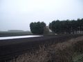
Coords lie somewhere between the trees and the fence (?)
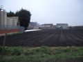
The point from the other side
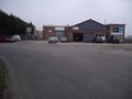
The front of the garage


Achievements
Angel earned the Puppet Master Geohash achievement
|