Difference between revisions of "2012-04-07 43 -2"
imported>Kydlt |
imported>FippeBot m (Location) |
||
| (3 intermediate revisions by 3 users not shown) | |||
| Line 25: | Line 25: | ||
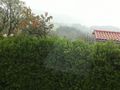
Image:2012-04-07 43 -2 01 driving into Urkimenda.jpg | Our closest bet for what town. | Image:2012-04-07 43 -2 01 driving into Urkimenda.jpg | Our closest bet for what town. | ||
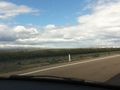
Image:2012-04-07 43 -2 02 end of the road.jpg | The end of the road. | Image:2012-04-07 43 -2 02 end of the road.jpg | The end of the road. | ||
| − | Image:2012-04-07 43 -2 03 ipad gps.jpg | | + | Image:2012-04-07 43 -2 03 ipad gps.jpg | We were totally off of any roads that were available offline on this app. I got better at preloading what we would need as the trip went on. |
| + | Image:2012-04-07 43 -2 04 wind farm.jpg | All over Spain there were major windfarms. Also big PV fields. | ||
</gallery> | </gallery> | ||
| + | [[Category:Expeditions]] | ||
| + | [[Category:Expeditions with photos]] | ||
| + | [[Category:Coordinates not reached]] | ||
| + | [[Category:Not reached - Technology]] | ||
| + | {{location|ES|PV|BI}} | ||
Latest revision as of 03:23, 13 August 2019
| Sat 7 Apr 2012 in 43,-2: 43.1885982, -2.8898827 geohashing.info google osm bing/os kml crox |
Location
In the Basque hill country near Ugao-Miraballes, Spain.
Participants
And his son/navigator/non-hasher, jgt.
Plans
I was in Spain having an adventure with my eldest. It involved driving from Barcelona up to the Atlantic coast, and then south to the Med coast, and back to Madrid. So many opportunities might present themselves.
Expedition
A fail. We got about 1 Km south of the spot. Ran out of road, ran out of map, and ran out of language. But a beautiful drive into the fog, drizzle and mountains. It could have been the Great Smokeys.
Photos

Our closest bet for what town.
The end of the road.

We were totally off of any roads that were available offline on this app. I got better at preloading what we would need as the trip went on.
All over Spain there were major windfarms. Also big PV fields.


