Difference between revisions of "2012-05-13 36 -76"
imported>ChrisG ([live picture] Tennis, amyone? [http://www.openstreetmap.org/?lat=36.86543389&lon=-76.28883418&zoom=16&layers=B000FTF @36.8654,-76.2888]) |
imported>ChrisG (→Expedition) |
||
| Line 29: | Line 29: | ||
== Expedition == | == Expedition == | ||
<!-- how it all turned out. your narrative goes here. --> | <!-- how it all turned out. your narrative goes here. --> | ||
| + | I'm still on the road, so this will be short for now. Took the long way from North Carolina to Rhode Island, because I wanted to go over (and through) the Chesapeake Bay Bridge/Tunnel. That there was an easy hashpoint along the way was a bonus. | ||
| + | We left Durham, NC at noon, and worked our way across NC and southeastern VA. Rolling hills, lots of trees, and farmland. Only one traffic tie-up, and that was within 2 miles of the hashpoint. | ||
| + | |||
| + | The hashpoint was on the grounds of a high school. | ||
| + | |||
| + | (more later) | ||
== Photos == | == Photos == | ||
Revision as of 14:25, 14 May 2012
| Sun 13 May 2012 in 36,-76: 36.8654550, -76.2888676 geohashing.info google osm bing/os kml crox |
Location
In Norfolk, Virginia, at some sort of park/athletic center on Llewellyn Avenue
Participants
ChrisG and WifeyGirl.
Plans
I'm driving from Durham, NC northward today toward Rhode Island, and this geohash is on one of my possible routes home. Hoping to be at the hash in the late afternoon, before I take the bridge/tunnel to DelMarVa.
Expedition
I'm still on the road, so this will be short for now. Took the long way from North Carolina to Rhode Island, because I wanted to go over (and through) the Chesapeake Bay Bridge/Tunnel. That there was an easy hashpoint along the way was a bonus.
We left Durham, NC at noon, and worked our way across NC and southeastern VA. Rolling hills, lots of trees, and farmland. Only one traffic tie-up, and that was within 2 miles of the hashpoint.
The hashpoint was on the grounds of a high school.
(more later)
Photos
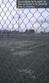
Tennis, amyone? @36.8654,-76.2888

Achievements