Difference between revisions of "2012-05-25 47 8"
From Geohashing
imported>Frizzy (→Photos: now.) |
imported>Frizzy (→Achievements: land) |
||
| Line 46: | Line 46: | ||
{{#vardefine:ribbonwidth|800px}} | {{#vardefine:ribbonwidth|800px}} | ||
<!-- Add any achievement ribbons you earned below, or remove this section --> | <!-- Add any achievement ribbons you earned below, or remove this section --> | ||
| + | |||
| + | {{land geohash | latitude = 47 | longitude = 8 | date = 2012-05-25| name = Hijackal, Frizzy and juggly friends}} | ||
Revision as of 16:57, 29 May 2012
| Fri 25 May 2012 in 47,8: 47.9327014, 8.0929830 geohashing.info google osm bing/os kml crox |
Location
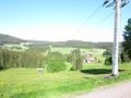
A meadow just off the B31 between Freiburg and Titisee
Participants
Plans
Hijackal, Frizzy and some dragalong jugglers are on their way to an extended weekend of camping on the shores of Lake Constance. The hash is too close (2km) to their projected route not to make the detour.
Expedition
Tracklog
Photos
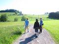
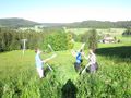
Parts of the group is heading towards the hash.
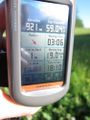
GPS-proof.
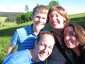
Yay! We got there :)
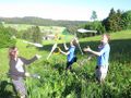
Juggling part 1.
Juggling part 2.
In winter times you can go skiing there...


Achievements
Hijackal, Frizzy and juggly friends earned the Land geohash achievement
|