Difference between revisions of "2012-06-10 52 4"
From Geohashing
imported>Murfie (→Expedition) |
imported>Murfie (→Photos) |
||
| Line 47: | Line 47: | ||
--> | --> | ||
<gallery perrow="5"> | <gallery perrow="5"> | ||
| + | |||
| + | Image:2012-06-10_52_4_0410.JPG| Windmill nearby | ||
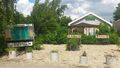
| + | Image:2012-06-10_52_4_0401.JPG| The geohash was located between a museum and a camping | ||
| + | Image:2012-06-10_52_4_0400.JPG| 2 white swans | ||
| + | Image:2012-09-10_52_4_0391.JPG| oops | ||
| + | Image:2012-06-10_52_4_0394.JPG| | ||
| + | Image:2012-06-10_52_4_0395.JPG| | ||
| + | Image:2012-06-10_52_4_0396.JPG| | ||
| + | Image:2012-06-10_52_4_0398.JPG| | ||
| + | Image:2012-06-10_52_4_0399.JPG| | ||
| + | |||
| + | |||
</gallery> | </gallery> | ||
Revision as of 19:37, 11 June 2012
| Sun 10 Jun 2012 in 52,4: 52.0537277, 4.7302875 geohashing.info google osm bing/os kml crox |
Location
Reeuwijk
Participants
Plans
Looks pretty reachable, but you never know. I'll try to step by somewhere in the afternoon.
Expedition
To get there, it was a car trip of less than an hour and a few minutes walk. Not very interesting.
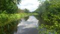
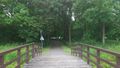
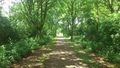
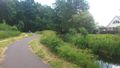
I had decided to just enter a random street in Reeuwijk in my car navigation and park somewhere I felt appropiate. When I stepped out of the car and fired up my GPS, it turned out I was less than 500m from the geohash. It was located on a bike road through a small park with a lot of trees and water, near a camping called 'Reeuwijkse Hout'.
Tracklog
Photos
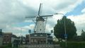
Windmill nearby
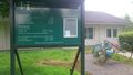
The geohash was located between a museum and a camping
2 white swans
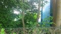
oops


Achievements