Difference between revisions of "2012-05-04 38 -95"
imported>QuantumCop |
imported>QuantumCop |
||
| Line 42: | Line 42: | ||
Image:2012-05-04_38_-95_proof.jpg | My proof of reaching the hashpoint. | Image:2012-05-04_38_-95_proof.jpg | My proof of reaching the hashpoint. | ||
Image:2012-05-04_38_-95_stupidgrin.jpg | Stupid Grin | Image:2012-05-04_38_-95_stupidgrin.jpg | Stupid Grin | ||
| − | Image:2012- | + | Image:2012-005-04_38_-95_field.jpg | A baseball field near the hashpoint. |
</gallery> | </gallery> | ||
Revision as of 03:44, 13 June 2012
| Fri 4 May 2012 in 38,-95: 38.6134706, -95.2861907 geohashing.info google osm bing/os kml crox |
Location
In a large field of dirt near a baseball field, in Ottawa, KS
Participants
Expedition
As usual, I began heading south down Iowa St./US 59. Near the hashpoint, there was a park with a baseball field and some batting cages. I got out of my car and walked along a small maintenance road along a hill overlooking the baseball field. The hashpoint was in a field on the opposite side of the hill, so I headed down towards it. The whole field was made of soft soil, and it looked like there may have been plants growing there at one point. The point wasn't too far out into the field, so I walked a little ways out, following my GPS. I snapped a few pictures of the area along with my proof and a Stupid Grin, and then headed out.
Photos
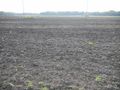
The hashpoint is somewhere in the middle of this picture.
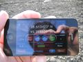
My proof of reaching the hashpoint.
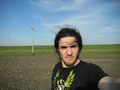
Stupid Grin
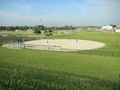
A baseball field near the hashpoint.


