Difference between revisions of "2012-06-07 33 -116"
From Geohashing
imported>LucasBrown (→Participants) |
imported>LucasBrown (→Plans) |
||
| Line 22: | Line 22: | ||
== Participants == | == Participants == | ||
[[User:LucasBrown|LucasBrown]] | [[User:LucasBrown|LucasBrown]] | ||
| − | |||
| − | |||
| − | |||
== Expedition == | == Expedition == | ||
Revision as of 00:31, 16 June 2012
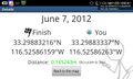
| Thu 7 Jun 2012 in 33,-116: 33.2988322, -116.5258616 geohashing.info google osm bing/os kml crox |
Location
Almost exactly one mile in elevation on the side of Hot Springs Mountain, amid a burned-out manzanita grove
Participants
Expedition
Tracklog
Photos
Geohash Droid details page at the hashpoint

Achievements