Difference between revisions of "2012-06-17 32 -117"
From Geohashing
imported>LucasBrown ([live picture] Less than a meter from the hashpoint [http://www.openstreetmap.org/?lat=32.81772680&lon=-117.05834874&zoom=16&layers=B000FTF @32.8177,-117.0583]) |
imported>LucasBrown ([live picture] The hashpoint [http://www.openstreetmap.org/?lat=32.81773336&lon=-117.05835033&zoom=16&layers=B000FTF @32.8177,-117.0584]) |
||
| Line 36: | Line 36: | ||
Image:2012-06-17_32_-117_12-12-18-792.jpg | Less than a meter from the hashpoint [http://www.openstreetmap.org/?lat=32.81772680&lon=-117.05834874&zoom=16&layers=B000FTF @32.8177,-117.0583] | Image:2012-06-17_32_-117_12-12-18-792.jpg | Less than a meter from the hashpoint [http://www.openstreetmap.org/?lat=32.81772680&lon=-117.05834874&zoom=16&layers=B000FTF @32.8177,-117.0583] | ||
| + | |||
| + | Image:2012-06-17_32_-117_12-13-01-146.jpg | The hashpoint [http://www.openstreetmap.org/?lat=32.81773336&lon=-117.05835033&zoom=16&layers=B000FTF @32.8177,-117.0584] | ||
</gallery> | </gallery> | ||
Revision as of 19:13, 17 June 2012
| Sun 17 Jun 2012 in 32,-117: 32.8176662, -117.0583536 geohashing.info google osm bing/os kml crox |
Location
Just off of Mission Gorge Rd, near Jackson Dr.
Participants
Plans
Going to head out as soon as possible, probably getting there by 10:30 AM. JesseW 12:29, 17 June 2012 (EDT)
Expedition
Tracklog
Photos
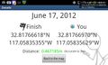
Less than a meter from the hashpoint @32.8177,-117.0583
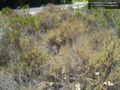
The hashpoint @32.8177,-117.0584


Achievements