Difference between revisions of "2012-07-13 53 6"
imported>Shevek (Created page with "{{subst:Expedition |lat = 53 |lon = 6 |date = 2012-07-13 }}") |
imported>FippeBot m (Location) |
||
| (5 intermediate revisions by 2 users not shown) | |||
| Line 1: | Line 1: | ||
| − | |||
| − | |||
| − | |||
| − | |||
| − | |||
| − | |||
| − | |||
| − | |||
| − | |||
| − | |||
{{meetup graticule | {{meetup graticule | ||
| lat=53 | | lat=53 | ||
| Line 15: | Line 5: | ||
}} | }} | ||
| − | |||
__NOTOC__ | __NOTOC__ | ||
== Location == | == Location == | ||
| − | + | In a field near Adorp | |
== Participants == | == Participants == | ||
| − | + | [[User:Shevek|Shevek]] | |
| − | |||
== Plans == | == Plans == | ||
| − | + | I have to be back home at 13:00, so I'm planning to go in the morning. I want to go there by bike. It should be a nice trip. Let's hope the weather is good. | |
== Expedition == | == Expedition == | ||
| − | + | Around 22:30 on the day before, I decided that I'd try to be there at midnight. However, I wanted to fix my bike before that. I had to print a spacer block for my support (yes, the bike can do without, but I had it in my house now, so I was going to fix it), which took some time. Eventually I left around 23:20, which was late. However, it wasn't very far. But it was very dark. I had taken a flash light, and I thought I had remembered what the place looked like. Perhaps I should just make some screen dumps of satellite images next time. I learn something new for each geohash. :-) | |
| − | + | Around 23:50 I arrived near the hash. I took out my netbook (which is my gps device) and checked (and took a picture. It was dark...). It was about 1 km away. I should have realized that I should have been closer before I couldn't cycle anymore. I walked through some fields, waking some sheep which were very vocal about it (but didn't seem to mind, they came to greet me, but ignored me when I walked on). I had then decided that I would get out of the field, but that wasn't as easy as it sounded. There was water everywhere. Eventually I found a way out. I walked back to my bike and rode a bit further, until I was in Adorp. Then I went left, to pass north of the hash. That worked, but as I had seen from home, there wasn't a way to the hash from there. I tried anyway, but then found a fence with a sign saying that, because this was a "resting area" (for birds, I suppose)), dogs were not allowed there, and otherwise the entrance was forbidden. Eh, right. They could have left out the part with the dogs, I think. | |
| − | + | ||
| + | Anyway, I didn't want to disturb the resting animals even more, so I decided to give up and go home. At the fence I was 345 meters from the hash, as can be seen on my screen dump. | ||
| + | |||
| + | Back home, I checked where I had been. The road which got me off the grass fields was the one I should have followed to get on them. For the rest my memory had served me well, and I had gone where I thought I went. | ||
== Photos == | == Photos == | ||
| − | |||
| − | |||
| − | |||
<gallery perrow="5"> | <gallery perrow="5"> | ||
| + | Image:2012-07-13_53-6_darkness.jpg | It was dark. | ||
| + | Image:2012-07-13_53-6_fence.jpg | The fence with the peculiar sign. | ||
| + | Image:2012-07-13_53-6_sign.jpg | No dogs allowed. Otherwise the entrance is forbidden. | ||
| + | Image:2012-7-13_53-6_screendump.png | 345 meters south of here. | ||
</gallery> | </gallery> | ||
== Achievements == | == Achievements == | ||
{{#vardefine:ribbonwidth|800px}} | {{#vardefine:ribbonwidth|800px}} | ||
| − | + | {{No trespassing | |
| + | | latitude = 53 | ||
| + | | longitude = 6 | ||
| + | | date = 2012-07-13 | ||
| + | | name = [[User:Shevek|Shevek]] | ||
| + | | image = 2012-07-13_53-6_sign.jpg | ||
| + | }} | ||
| − | |||
| − | |||
| − | |||
| − | |||
| − | |||
| − | |||
| − | |||
| − | |||
| − | |||
| − | |||
[[Category:Expeditions]] | [[Category:Expeditions]] | ||
| − | |||
[[Category:Expeditions with photos]] | [[Category:Expeditions with photos]] | ||
| − | |||
| − | |||
| − | |||
| − | |||
| − | |||
| − | |||
| − | |||
| − | |||
| − | |||
[[Category:Coordinates not reached]] | [[Category:Coordinates not reached]] | ||
| − | |||
| − | |||
| − | |||
| − | |||
| − | |||
[[Category:Not reached - No public access]] | [[Category:Not reached - No public access]] | ||
| − | + | [[Category:Shevek]] | |
| − | + | {{location|NL|GR}} | |
| − | [[Category: | ||
| − | |||
| − | |||
| − | |||
| − | |||
| − | |||
Latest revision as of 05:01, 13 August 2019
| Fri 13 Jul 2012 in 53,6: 53.2720063, 6.5272212 geohashing.info google osm bing/os kml crox |
Location
In a field near Adorp
Participants
Plans
I have to be back home at 13:00, so I'm planning to go in the morning. I want to go there by bike. It should be a nice trip. Let's hope the weather is good.
Expedition
Around 22:30 on the day before, I decided that I'd try to be there at midnight. However, I wanted to fix my bike before that. I had to print a spacer block for my support (yes, the bike can do without, but I had it in my house now, so I was going to fix it), which took some time. Eventually I left around 23:20, which was late. However, it wasn't very far. But it was very dark. I had taken a flash light, and I thought I had remembered what the place looked like. Perhaps I should just make some screen dumps of satellite images next time. I learn something new for each geohash. :-)
Around 23:50 I arrived near the hash. I took out my netbook (which is my gps device) and checked (and took a picture. It was dark...). It was about 1 km away. I should have realized that I should have been closer before I couldn't cycle anymore. I walked through some fields, waking some sheep which were very vocal about it (but didn't seem to mind, they came to greet me, but ignored me when I walked on). I had then decided that I would get out of the field, but that wasn't as easy as it sounded. There was water everywhere. Eventually I found a way out. I walked back to my bike and rode a bit further, until I was in Adorp. Then I went left, to pass north of the hash. That worked, but as I had seen from home, there wasn't a way to the hash from there. I tried anyway, but then found a fence with a sign saying that, because this was a "resting area" (for birds, I suppose)), dogs were not allowed there, and otherwise the entrance was forbidden. Eh, right. They could have left out the part with the dogs, I think.
Anyway, I didn't want to disturb the resting animals even more, so I decided to give up and go home. At the fence I was 345 meters from the hash, as can be seen on my screen dump.
Back home, I checked where I had been. The road which got me off the grass fields was the one I should have followed to get on them. For the rest my memory had served me well, and I had gone where I thought I went.
Photos
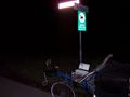
It was dark.
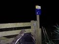
The fence with the peculiar sign.

No dogs allowed. Otherwise the entrance is forbidden.
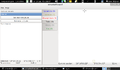
345 meters south of here.


Achievements
Shevek earned the No trespassing consolation prize
|