Difference between revisions of "2012-08-06 52 -3"
imported>Huinesoron (Starting this one) |
imported>Huinesoron (Preparation section done) |
||
| Line 1: | Line 1: | ||
| − | |||
<!-- If you did not specify these parameters in the template, please substitute appropriate values for IMAGE, LAT, LON, and DATE (YYYY-MM-DD format) | <!-- If you did not specify these parameters in the template, please substitute appropriate values for IMAGE, LAT, LON, and DATE (YYYY-MM-DD format) | ||
| Line 15: | Line 14: | ||
}} | }} | ||
| − | |||
__NOTOC__ | __NOTOC__ | ||
== Location == | == Location == | ||
| − | + | While most of the Mid Wales graticule lies far, far away from anything, this particular hashpoint sits on a low hill right by the river Mawddach. Sure, the hill's forested and may not have any paths in it - but that's no problem, right? | |
== Participants == | == Participants == | ||
| − | + | *[[User:Huinesoron|Huinesoron]] | |
| − | -- | + | *Huinesoron's mother |
| + | |||
| + | == Preparation == | ||
| + | From Saturday 4th through Friday 10th August, I was staying a short distance south of this hashpoint (my journey there allowed me to hit my first ever hash [[2012-08-04 51 -0|on the Saturday]]), right on the border between two virgin graticules, so I had a prime opportunity for geohashing. Unfortunately, [[Aberystwyth, United Kingdom| Aberystwyth]] graticule is mostly underwater... and Wales is very bad for internet access... so I had a total of three possible hashes: Saturday, Sunday, and (because we're east of 30W) Monday. Saturday and Sunday were too far. Monday... was just right. | ||
| + | |||
| + | Oh, but no internet means no GPS even on a phone - so this was a map job. I pulled the map off the shelf and... cursed, because the map grid ''of course'' isn't aligned to the lat/long grid. Fortunately there were graticule intersections marked, but it was still more work than I'd been expecting - and the forest was so small! Surely there had to be a larger-scale map. | ||
| + | |||
| + | There was. That one ''didn't'' have graticule-intersection marks. Cue some overly-complicated ruler work to pinpoint the hash (hey, it's been a decade since I last used a map this way, cut me some slack!). At least the second map showed some actual tracks... a tentative route was planned. Three routes, actually. Since the hashpoint itself was off-track, we could compass either from the end of a wall (blue option), a corner in the path (red), or along a contour (yellow). | ||
| + | |||
| + | But this is Geohashing. It was never going to be that simple... | ||
| − | = | + | <gallery perrow="5"> |
| − | + | Image:2012-08-06 52 -3 Maths.jpg | Sums hurt my head | |
| + | Image:2012-08-06 52 -3 Rulerwork.jpg | But this hurts more than the sums | ||
| + | Image:2012-08-06 52 -3 Plainmap.jpg | Where we're going | ||
| + | Image:2012-08-06 52 -3 Routemap.jpg | How we (might) get there | ||
| + | </gallery> | ||
== Expedition == | == Expedition == | ||
<!-- how it all turned out. your narrative goes here. --> | <!-- how it all turned out. your narrative goes here. --> | ||
| − | |||
| − | |||
| − | |||
== Photos == | == Photos == | ||
| Line 49: | Line 57: | ||
[[Category:New report]] | [[Category:New report]] | ||
| − | + | ||
| − | |||
| − | |||
| − | |||
<!-- An actual expedition: | <!-- An actual expedition: | ||
[[Category:Expeditions]] | [[Category:Expeditions]] | ||
| − | |||
[[Category:Expeditions with photos]] | [[Category:Expeditions with photos]] | ||
| − | |||
[[Category:Expedition without GPS]] | [[Category:Expedition without GPS]] | ||
--> | --> | ||
| Line 66: | Line 69: | ||
| − | + | --> | |
| − | |||
| − | |||
| − | |||
| − | |||
| − | |||
| − | |||
| − | |||
| − | |||
| − | |||
| − | |||
| − | |||
| − | |||
| − | |||
| − | |||
| − | |||
Revision as of 15:29, 12 August 2012
| Mon 6 Aug 2012 in 52,-3: 52.7405222, -3.9588775 geohashing.info google osm bing/os kml crox |
Location
While most of the Mid Wales graticule lies far, far away from anything, this particular hashpoint sits on a low hill right by the river Mawddach. Sure, the hill's forested and may not have any paths in it - but that's no problem, right?
Participants
- Huinesoron
- Huinesoron's mother
Preparation
From Saturday 4th through Friday 10th August, I was staying a short distance south of this hashpoint (my journey there allowed me to hit my first ever hash on the Saturday), right on the border between two virgin graticules, so I had a prime opportunity for geohashing. Unfortunately, Aberystwyth graticule is mostly underwater... and Wales is very bad for internet access... so I had a total of three possible hashes: Saturday, Sunday, and (because we're east of 30W) Monday. Saturday and Sunday were too far. Monday... was just right.
Oh, but no internet means no GPS even on a phone - so this was a map job. I pulled the map off the shelf and... cursed, because the map grid of course isn't aligned to the lat/long grid. Fortunately there were graticule intersections marked, but it was still more work than I'd been expecting - and the forest was so small! Surely there had to be a larger-scale map.
There was. That one didn't have graticule-intersection marks. Cue some overly-complicated ruler work to pinpoint the hash (hey, it's been a decade since I last used a map this way, cut me some slack!). At least the second map showed some actual tracks... a tentative route was planned. Three routes, actually. Since the hashpoint itself was off-track, we could compass either from the end of a wall (blue option), a corner in the path (red), or along a contour (yellow).
But this is Geohashing. It was never going to be that simple...
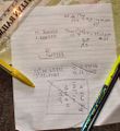
Sums hurt my head
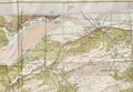
But this hurts more than the sums
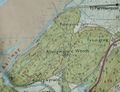
Where we're going
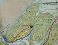
How we (might) get there


Expedition
Photos
Achievements