Difference between revisions of "2012-09-21 43 -90"
From Geohashing
imported>Swensonj (→Photos: add) |
imported>Swensonj (→Achievements: ribbons) |
||
| Line 40: | Line 40: | ||
{{#vardefine:ribbonwidth|800px}} | {{#vardefine:ribbonwidth|800px}} | ||
<!-- Add any achievement ribbons you earned below, or remove this section --> | <!-- Add any achievement ribbons you earned below, or remove this section --> | ||
| + | {{land geohash | ||
| + | | latitude = 43 | ||
| + | | longitude = -90 | ||
| + | | date = 2012-09-21 | ||
| + | | name = SwensonJ | ||
| + | | image = 2012-09-21 43 -90 Fog.jpg | ||
| − | + | }} | |
| − | |||
| − | |||
| − | + | {{Midnight geohash | |
| − | |||
| − | |||
| − | |||
| − | + | | latitude = 43 | |
| − | + | | longitude = -90 | |
| − | -- | + | | date = 2012-09-21 |
| − | + | | name = SwensonJ | |
| − | + | | image = 2012-09-21 43 -90 Proof.jpg | |
| − | |||
| − | -- | ||
| − | |||
| − | |||
| − | |||
| + | }} | ||
| − | + | {{Virgin graticule | |
| − | |||
| − | |||
| − | |||
| − | |||
| − | |||
| − | |||
| − | |||
| − | + | | latitude = 43 | |
| − | + | | longitude = -90 | |
| − | + | | date = 2012-09-21 | |
| − | + | | name = SwensonJ | |
| − | + | | image = 2012-09-21 43 -90 Fog.jpg | |
| − | + | }} | |
| + | <!-- =============== USEFUL CATEGORIES FOLLOW ================ | ||
| + | [[Category:Expeditions]] | ||
| + | [[Category:Expeditions with photos]] | ||
| + | [[Category:Coordinates reached]] | ||
Revision as of 16:38, 22 September 2012
| Fri 21 Sep 2012 in 43,-90: 43.0636770, -90.4954511 geohashing.info google osm bing/os kml crox |
Location
Wooded area northeast of Fennimore, Wisconsin. SwensonJ is thinking about a late-night run to this one. Idiocy? Only if I actually go....
Participants
Plans
Run out after the kids go to bed. Maybe do some cleaning and then try for the Midnight Geohash?
Expedition
Photos
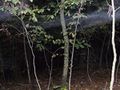
Here's what it would have looked like if I could see
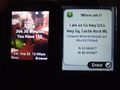
Here's where and when


Achievements
SwensonJ earned the Land geohash achievement
|
SwensonJ earned the Midnight Geohash achievement
|