Difference between revisions of "2012-09-21 50 13"
imported>Ravise (Creation of page) |
imported>FippeBot m (Location) |
||
| (2 intermediate revisions by one other user not shown) | |||
| Line 1: | Line 1: | ||
| − | |||
| − | |||
| − | |||
| − | |||
| − | |||
| − | |||
| − | |||
| − | |||
| − | |||
| − | |||
{{meetup graticule | {{meetup graticule | ||
| lat=50 | | lat=50 | ||
| Line 14: | Line 4: | ||
| date=2012-09-21 | | date=2012-09-21 | ||
}} | }} | ||
| − | + | '''Warning: My english is not as good as I want. Page may contain non-existing words and bad prepositions. I apologize.''' | |
| − | |||
__NOTOC__ | __NOTOC__ | ||
== Location == | == Location == | ||
| − | + | 350m in fields near Volevčice village | |
== Participants == | == Participants == | ||
| − | < | + | [[User:Ravise | Ravise]]<br> |
| − | + | Jack | |
| − | |||
== Plans == | == Plans == | ||
| − | + | Leave from Most on 15:37 and travel by train to Volevčice. | |
== Expedition == | == Expedition == | ||
| − | + | After my first expedition I told to friend of mine about it and gave him appropriate links. The day before I wrote him SMS about one hashpoint near Most. We decided to participate. | |
| − | + | We arrived to Volevčice train station (the village was build due to coal power station, by the way the most dirty one in country) and imminently we left to the hashpoint. After crossing two crossroads we wanted to turn on Google Maps app in my mobile. I think we were quite near hashpoint, but unfortunately there was no signal. So we can't prove being AT the hashpoint, but we think in the principle we did it. We discovered the power station is only twelve kilometers far! The dirtiest one! | |
| − | |||
== Photos == | == Photos == | ||
| Line 38: | Line 25: | ||
--> | --> | ||
<gallery perrow="5"> | <gallery perrow="5"> | ||
| + | File:2012-09-15 50 13 elektrarna.JPG| Power station near train stop | ||
| + | File:2012-09-15 50 13 zastavka.JPG| We left the train and saw this | ||
| + | File:2012-09-15 50 13 poster.JPG| Maybe somebody will move it to right location | ||
| + | File:2012-09-15 50 13 grins.JPG| Two stupid grins | ||
</gallery> | </gallery> | ||
== Achievements == | == Achievements == | ||
| − | {{ | + | {{Radio Yerevan |
| − | + | | achievement = Land geohash | |
| + | | detail = we still think geohash was one field to right | ||
| + | | date = 2012-09-21 | ||
| + | | latitude = 50 | ||
| + | | longitude = 13 | ||
| + | | user = Jack | ||
| + | }} | ||
| + | {{Radio Yerevan | ||
| + | | achievement = No batteries geohash | ||
| + | | detail = we still think geohash was one field to right | ||
| + | | date = 2012-09-21 | ||
| + | | latitude = 50 | ||
| + | | longitude = 13 | ||
| + | | user = Jack | ||
| + | }} | ||
| − | |||
| − | |||
| − | |||
| − | |||
| − | |||
| − | |||
| − | |||
| − | |||
| − | |||
| − | |||
| − | |||
[[Category:Expeditions]] | [[Category:Expeditions]] | ||
| − | |||
[[Category:Expeditions with photos]] | [[Category:Expeditions with photos]] | ||
| − | |||
| − | |||
| − | |||
| − | |||
| − | |||
| − | |||
| − | |||
| − | |||
| − | |||
[[Category:Coordinates not reached]] | [[Category:Coordinates not reached]] | ||
| − | |||
| − | |||
| − | |||
| − | |||
| − | |||
| − | |||
| − | |||
| − | |||
[[Category:Not reached - Technology]] | [[Category:Not reached - Technology]] | ||
| − | + | {{location|CZ|US|5}} | |
| − | |||
| − | |||
| − | |||
| − | |||
Latest revision as of 06:13, 13 August 2019
| Fri 21 Sep 2012 in 50,13: 50.4302360, 13.7126409 geohashing.info google osm bing/os kml crox |
Warning: My english is not as good as I want. Page may contain non-existing words and bad prepositions. I apologize.
Location
350m in fields near Volevčice village
Participants
Ravise
Jack
Plans
Leave from Most on 15:37 and travel by train to Volevčice.
Expedition
After my first expedition I told to friend of mine about it and gave him appropriate links. The day before I wrote him SMS about one hashpoint near Most. We decided to participate.
We arrived to Volevčice train station (the village was build due to coal power station, by the way the most dirty one in country) and imminently we left to the hashpoint. After crossing two crossroads we wanted to turn on Google Maps app in my mobile. I think we were quite near hashpoint, but unfortunately there was no signal. So we can't prove being AT the hashpoint, but we think in the principle we did it. We discovered the power station is only twelve kilometers far! The dirtiest one!
Photos
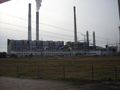
Power station near train stop

We left the train and saw this
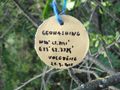
Maybe somebody will move it to right location
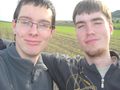
Two stupid grins


Achievements
Is it true that Jack earned the Land geohash?
|
Is it true that Jack earned the No batteries geohash?
|