Difference between revisions of "2012-10-11 48 7"
From Geohashing
imported>Frizzy ([live] Almost there!) |
imported>Frizzy ([live picture] Almost there! [http://www.openstreetmap.org/?lat=48.18514751&lon=7.67996815&zoom=16&layers=B000FTF @48.1851,7.6800]) |
||
| Line 40: | Line 40: | ||
Image:2012-10-11_48_7_12-09-26-118.jpg | Nice view on Riegel am Kaiserstuhl, where Elz is joining Dreisam. [http://www.openstreetmap.org/?lat=48.14697058&lon=7.75614347&zoom=16&layers=B000FTF @48.1470,7.7561] | Image:2012-10-11_48_7_12-09-26-118.jpg | Nice view on Riegel am Kaiserstuhl, where Elz is joining Dreisam. [http://www.openstreetmap.org/?lat=48.14697058&lon=7.75614347&zoom=16&layers=B000FTF @48.1470,7.7561] | ||
| + | |||
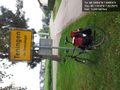
| + | Image:2012-10-11_48_7_12-56-40-498.jpg | Almost there! [http://www.openstreetmap.org/?lat=48.18514751&lon=7.67996815&zoom=16&layers=B000FTF @48.1851,7.6800] | ||
</gallery> | </gallery> | ||
Revision as of 10:57, 11 October 2012
| Thu 11 Oct 2012 in 48,7: 48.1856507, 7.6800425 geohashing.info google osm bing/os kml crox |
Location
On a field south of Weisweil
Participants
Plans
- Frizzy
- Damaged machines prevent me from work tomorrow, so I want to start the trip somewhen after breakfast by bike. Distance one way: ~ 25km --> something between one and two hours...
Expedition
- First stop for right navigation...Frizzy chose to turn left. -- Frizzy @48.0840,7.8623 11:05, 11 October 2012 (CEST)
- Picknick! :-) -- Frizzy @48.1390,7.7857 11:49, 11 October 2012 (CEST)
- Almost there! -- Frizzy @48.1852,7.6800 12:55, 11 October 2012 (CEST)
Photos
First station is reached! @48.1182,7.8226
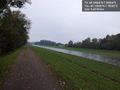
...and for about six kilometers the way looks like that... @48.1390,7.7858
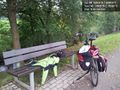
Picknick place @48.1391,7.7858
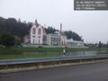
Nice view on Riegel am Kaiserstuhl, where Elz is joining Dreisam. @48.1470,7.7561
Almost there! @48.1851,7.6800


