Difference between revisions of "2012-10-15 60 22"
From Geohashing
imported>Suurnesu (→Participants) |
imported>Suurnesu (→Participants) |
||
| Line 24: | Line 24: | ||
<!-- who attended: If you link to your wiki user name in this section, your expedition will be picked up by the various statistics generated for geohashing. You may use three tildes ~ as a shortcut to automatically insert the user signature of the account you are editing with. | <!-- who attended: If you link to your wiki user name in this section, your expedition will be picked up by the various statistics generated for geohashing. You may use three tildes ~ as a shortcut to automatically insert the user signature of the account you are editing with. | ||
--> | --> | ||
| − | Suurnesu | + | [[User:Suurnesu|suurnesu]] |
== Plans == | == Plans == | ||
Revision as of 18:35, 15 October 2012
| Mon 15 Oct 2012 in 60,22: 60.4538044, 22.1561817 geohashing.info google osm bing/os kml crox |
Location
Hashpoint ended up in an easily accesible cycleway some kilometers west from Turku city centre, in Perno suburb.
Participants
Plans
Expedition
- Test -- suurnesu @60.4545,22.1565 13:44, 15 October 2012 (EDT)
Tracklog
Photos

In Perno @60.4539,22.1564
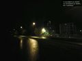
Rainy street


Achievements