Difference between revisions of "2012-11-20 32 -116"
From Geohashing
imported>LucasBrown ([live picture] Small cairn constructed at the hashpoint [http://www.openstreetmap.org/?lat=32.66683066&lon=-116.91910069&zoom=16&layers=B000FTF @32.6668,-116.9191]) |
imported>LucasBrown ([live picture] View from the hashpoint of Mount San Miguel and the community of Bella Lago [http://www.openstreetmap.org/?lat=32.66685843&lon=-116.91908319&zoom=16&layers=B000FTF @32.6669,-116.9191]) |
||
| Line 44: | Line 44: | ||
Image:2012-11-20_32_-116_11-35-59-199.jpg | Small cairn constructed at the hashpoint [http://www.openstreetmap.org/?lat=32.66683066&lon=-116.91910069&zoom=16&layers=B000FTF @32.6668,-116.9191] | Image:2012-11-20_32_-116_11-35-59-199.jpg | Small cairn constructed at the hashpoint [http://www.openstreetmap.org/?lat=32.66683066&lon=-116.91910069&zoom=16&layers=B000FTF @32.6668,-116.9191] | ||
| + | |||
| + | Image:2012-11-20_32_-116_11-37-39-583.jpg | View from the hashpoint of Mount San Miguel and the community of Bella Lago [http://www.openstreetmap.org/?lat=32.66685843&lon=-116.91908319&zoom=16&layers=B000FTF @32.6669,-116.9191] | ||
</gallery> | </gallery> | ||
Revision as of 19:37, 20 November 2012
| Tue 20 Nov 2012 in 32,-116: 32.6668560, -116.9190832 geohashing.info google osm bing/os kml crox |
Location
Participants
Plans
Expedition
Tracklog
Photos

Geohash Droid details page at the hashpoint @32.6668,-116.9191
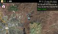
Map at the hashpoint @32.6668,-116.9191
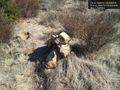
Small cairn constructed at the hashpoint @32.6668,-116.9191
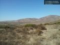
View from the hashpoint of Mount San Miguel and the community of Bella Lago @32.6669,-116.9191


Achievements