Difference between revisions of "2012-12-09 42 -88"
imported>Haberdasher (→Expedition) |
imported>FippeBot m (Location) |
||
| (4 intermediate revisions by one other user not shown) | |||
| Line 23: | Line 23: | ||
The hashpoint, or at least our closest approach to it, really was on the way in between errands, so getting there wasn't an issue. | The hashpoint, or at least our closest approach to it, really was on the way in between errands, so getting there wasn't an issue. | ||
| − | I knew, going into this, that I probably couldn't reach the hashpoint. However, I quickly discovered upon turning the corner that | + | |
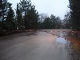
| + | I knew, going into this, that I probably couldn't reach the hashpoint, since it was clearly on company property likely not open to the public. However, I quickly discovered upon turning the corner that my closest approach would be even further from the hash than I thought. I'd discovered through Google Maps that the road had two branches, one to the left containing a building and cars in an orderly arrangement and one to the right containing rocks and a clearing, the latter branch containing the hashpoint. I had assumed that the left branch was a parking lot and store for the Brickman Group landscaping company which owned the property, and that the right branch would be fenced off. Instead, a sign helpfully informed me that the property was "Brickman Deliveries", while the gate in front of us similarly informed me that both branches were in fact off-limits to outsiders like me. The left branch was presumably a storage area, then, and the parking lot one for delivery trucks rather than customers. I took pictures of the sign, gate, and GPS before heading off into the quickly-darkening night. | ||
== Pictures == | == Pictures == | ||
<gallery widths=117px perrow="5"> | <gallery widths=117px perrow="5"> | ||
| + | Image:2012-12-09_42_-88Gate.JPG | No Trespassing | ||
| + | Image:2012-12-09_42_-88Sign.JPG | Brickman Deliveries | ||
| + | Image:2012-12-09_42_-88GPS.JPG | GPS on Closest Approach | ||
</gallery> | </gallery> | ||
| − | [[Category: | + | == Achievements == |
| + | |||
| + | {{No trespassing | ||
| + | | latitude = 42 | ||
| + | | longitude = -88 | ||
| + | | date = 2012-12-09 | ||
| + | | name = Haberdasher | ||
| + | }} | ||
| + | |||
| + | [[Category:Expeditions]] | ||
| + | [[Category:Coordinates not reached]] | ||
| + | [[Category:Not reached - No public access]] | ||
| + | {{location|US|IL|LK}} | ||
Latest revision as of 00:09, 14 August 2019
| Sun 9 Dec 2012 in Schaumburg, Illinois: 42.1711597, -88.0247772 geohashing.info google osm bing/os kml crox |
Location
On the property of a landscaping business in Long Grove.
Planning
- I doubt I'll be able to reach the hashpoint itself, but since I'll be nearby anyway, I'll swing by and give it a shot that afternoon. -Haberdasher 13:15, 7 December 2012 (EST)
Participants
Expedition
The hashpoint, or at least our closest approach to it, really was on the way in between errands, so getting there wasn't an issue.
I knew, going into this, that I probably couldn't reach the hashpoint, since it was clearly on company property likely not open to the public. However, I quickly discovered upon turning the corner that my closest approach would be even further from the hash than I thought. I'd discovered through Google Maps that the road had two branches, one to the left containing a building and cars in an orderly arrangement and one to the right containing rocks and a clearing, the latter branch containing the hashpoint. I had assumed that the left branch was a parking lot and store for the Brickman Group landscaping company which owned the property, and that the right branch would be fenced off. Instead, a sign helpfully informed me that the property was "Brickman Deliveries", while the gate in front of us similarly informed me that both branches were in fact off-limits to outsiders like me. The left branch was presumably a storage area, then, and the parking lot one for delivery trucks rather than customers. I took pictures of the sign, gate, and GPS before heading off into the quickly-darkening night.
Pictures
No Trespassing
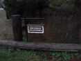
Brickman Deliveries
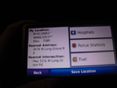
GPS on Closest Approach


Achievements
Haberdasher earned the No trespassing consolation prize
|