Difference between revisions of "2012-12-23 29 -81"
From Geohashing
imported>Grumpa (Created page with "{{subst:Expedition |lat = 29 |lon = -81 |date = 2012-12-23 }}") |
imported>Grumpa |
||
| Line 1: | Line 1: | ||
| − | |||
<!-- If you did not specify these parameters in the template, please substitute appropriate values for IMAGE, LAT, LON, and DATE (YYYY-MM-DD format) | <!-- If you did not specify these parameters in the template, please substitute appropriate values for IMAGE, LAT, LON, and DATE (YYYY-MM-DD format) | ||
| Line 18: | Line 17: | ||
__NOTOC__ | __NOTOC__ | ||
== Location == | == Location == | ||
| − | + | Forested area seoutheast of Palatka, Florida. | |
== Participants == | == Participants == | ||
| − | + | [[User:Grumpa|Grumpa]] | |
| − | |||
== Plans == | == Plans == | ||
| − | + | Fly over the hash point in an effort to earn the multihash achievement. | |
== Expedition == | == Expedition == | ||
<!-- how it all turned out. your narrative goes here. --> | <!-- how it all turned out. your narrative goes here. --> | ||
| − | |||
| − | |||
== Photos == | == Photos == | ||
| − | |||
| − | |||
| − | |||
<gallery perrow="5"> | <gallery perrow="5"> | ||
| + | Image:2012-12-23_29_-81_01.jpg | Descending from the previous Mile High award, looking north over Gainesville, Florida | ||
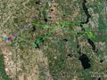
| + | Image:2012-12-23_29_-81_02.jpg | My two passes over the hash point in the Daytone Beach graticule | ||
| + | Image:2012-12-23_29_-81_03.jpg | Close-up of the first pass. I'm about 145' away. | ||
| + | Image:2012-12-23_29_-81_04.jpg | My flight path in the area | ||
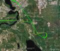
| + | Image:2012-12-23_29_-81_05.jpg | My entire path for the day. 1.6 hours on the Hobbs meter. | ||
| + | |||
| + | |||
</gallery> | </gallery> | ||
== Achievements == | == Achievements == | ||
{{#vardefine:ribbonwidth|800px}} | {{#vardefine:ribbonwidth|800px}} | ||
| − | + | {{Multihash | latitude1 = 29 | longitude1 = -82 | latitude2 = 29 | longitude2 = -81 | date = 2012-12-23 | name = [[User:Grumpa|Grumpa]] }} | |
| + | |||
Revision as of 22:09, 24 December 2012
| Sun 23 Dec 2012 in 29,-81: 29.5585921, -81.5100048 geohashing.info google osm bing/os kml crox |
Location
Forested area seoutheast of Palatka, Florida.
Participants
Plans
Fly over the hash point in an effort to earn the multihash achievement.
Expedition
Photos
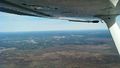
Descending from the previous Mile High award, looking north over Gainesville, Florida
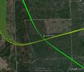
My two passes over the hash point in the Daytone Beach graticule
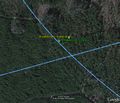
Close-up of the first pass. I'm about 145' away.
My flight path in the area
My entire path for the day. 1.6 hours on the Hobbs meter.


Achievements
Grumpa earned the Multihash Achievement
|