Difference between revisions of "2012-12-26 45 -92"
From Geohashing
imported>Swensonj (initial data entry) |
imported>Swensonj (→Photos: gallery) |
||
| Line 22: | Line 22: | ||
Image:2012-##-## ## ## Alpha.jpg | Witty Comment | Image:2012-##-## ## ## Alpha.jpg | Witty Comment | ||
--> | --> | ||
| − | <gallery perrow=" | + | <gallery perrow="4"> |
| + | Image:2012-12-26_45_-92_Proof.JPG | We were really there... | ||
| + | Image:2012-12-26_45_-92_Temp.JPG | ...and it was really cold. | ||
| + | Image:2012-12-26_45_-92_IceTea.JPG | The leftover drops of my wife's tea froze almost immediately. | ||
| + | Image:2012-12-26_45_-92_Bird.JPG | A fairly big bird had visited the hash before us. | ||
| + | Image:2012-12-26_45_-92_Grin.JPG | I had my picture taken at the hashpoint; | ||
| + | Image:2012-12-26_45_-92_Family.JPG | so did my family. | ||
| + | Image:2012-12-26_45_-92_ElbowLake.JPG | This is Elbow Lake, as seen from the hashpoint. | ||
| + | Image:2012-12-26_45_-92_Speed.JPG | We drove away through the hash at the posted speed limit: yay! | ||
</gallery> | </gallery> | ||
Revision as of 23:55, 26 December 2012
| Wed 26 Dec 2012 in 45,-92: 45.7411570, -92.4145576 geohashing.info google osm bing/os kml crox |
Location
North shoulder of Elbow Lake Road: west of Wisconsin State Highway 35, south of Siren, Wisconsin
Participants
Plans
We'll catch this on the road from Superior to Minneapolis, hopefully before sunset.
Expedition
Photos
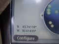
We were really there...
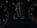
...and it was really cold.
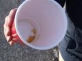
The leftover drops of my wife's tea froze almost immediately.
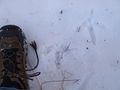
A fairly big bird had visited the hash before us.
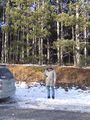
I had my picture taken at the hashpoint;
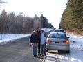
so did my family.
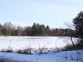
This is Elbow Lake, as seen from the hashpoint.
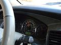
We drove away through the hash at the posted speed limit: yay!


Achievements