Difference between revisions of "1977-02-25 42 -90"
From Geohashing
imported>Swensonj (move image) |
imported>Swensonj (gallery and top image) |
||
| Line 1: | Line 1: | ||
| − | {{meetup graticule | + | {| class="wikitable" |
| − | | lat=42 | + | |- |
| − | | lon=-90 | + | | [[File:2013-01-05_42_-90 DoubleMap.PNG|400px|thumb|left|Map of both hashpoints]] |
| − | | date=1977-02-25 | + | | {{meetup graticule |
| − | }} | + | | lat=42 |
| + | | lon=-90 | ||
| + | | date=1977-02-25 | ||
| + | }} | ||
| + | |} | ||
__NOTOC__ | __NOTOC__ | ||
== Location == | == Location == | ||
| − | Off County Road N, east of Beetown, Wisconsin | + | Off County Road N, east of Beetown, Wisconsin, about a mile south of [[2013-01-05 42 -90]]. |
== Participants == | == Participants == | ||
| − | [[User:Swensonj| | + | [[User:Swensonj|SwensonJ]] |
== Plans == | == Plans == | ||
I'll try to visit this one on my way to an XKCD meetup at [[2013-01-05 42 -90]]. | I'll try to visit this one on my way to an XKCD meetup at [[2013-01-05 42 -90]]. | ||
| − | |||
== Expedition == | == Expedition == | ||
| − | + | This is part two of a pseudomultihash: you can also read about [[2013-01-05 42 -90|part one]]. | |
== Photos == | == Photos == | ||
| − | |||
| − | |||
| − | |||
<gallery perrow="5"> | <gallery perrow="5"> | ||
| + | Image:1977-02-25 42 -90 Calf.jpg | My kids were very happy to see calves... | ||
| + | Image:1977-02-25 42 -90 Horse.jpg | ...and horses. | ||
| + | Image:1977-02-25 42 -90 Host.jpg | This young man lives at the hash; his dad gave us permission to walk across the fields. | ||
| + | Image:1977-02-25 42 -90 Neighbor.jpg | The neighboring farm to the west. | ||
| + | Image:1977-02-25 42 -90 Rest.jpg | My son rests near the hashpoint. | ||
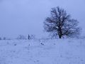
| + | Image:1977-02-25 42 -90 Tree.jpg | This tree is almost at the end of our trip. | ||
| + | Image:1977-02-25 42 -90 Proof.jpg | We got to the right place... | ||
| + | Image:1977-02-25 42 -90 Grin.jpg | ...and I was happy there... | ||
| + | Image:1977-02-25 42 -90 Kids.jpg | ...as were my kids. | ||
| + | Image:1977-02-25 42 -90 Hash.jpg | This is the view from the hashpoint. | ||
</gallery> | </gallery> | ||
| Line 33: | Line 43: | ||
<!-- =============== USEFUL CATEGORIES FOLLOW ================ | <!-- =============== USEFUL CATEGORIES FOLLOW ================ | ||
| − | |||
| − | |||
| − | |||
[[Category:Expeditions]] | [[Category:Expeditions]] | ||
| − | |||
[[Category:Expeditions with photos]] | [[Category:Expeditions with photos]] | ||
| − | [[Category: | + | [[Category:Retro coordinates reached]] |
| − | |||
| − | |||
| − | |||
| − | |||
| − | |||
| − | |||
| − | |||
| − | |||
| − | |||
| − | |||
| − | |||
| − | |||
| − | |||
| − | |||
| − | |||
| − | |||
| − | |||
| − | |||
| − | |||
| − | |||
| − | |||
| − | |||
| − | |||
Revision as of 04:27, 6 January 2013
| |||||||

Location
Off County Road N, east of Beetown, Wisconsin, about a mile south of 2013-01-05 42 -90.
Participants
Plans
I'll try to visit this one on my way to an XKCD meetup at 2013-01-05 42 -90.
Expedition
This is part two of a pseudomultihash: you can also read about part one.
Photos
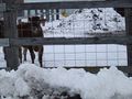
My kids were very happy to see calves...
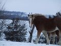
...and horses.
This young man lives at the hash; his dad gave us permission to walk across the fields.
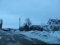
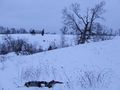
The neighboring farm to the west.
My son rests near the hashpoint.
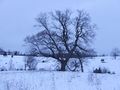
This tree is almost at the end of our trip.
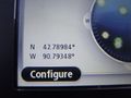
We got to the right place...
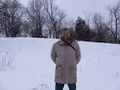
...and I was happy there...
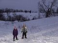
...as were my kids.
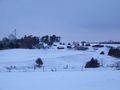
This is the view from the hashpoint.


