Difference between revisions of "2013-02-04 52 20"
imported>Ziemek |
imported>Norill |
||
| Line 46: | Line 46: | ||
== Photos == | == Photos == | ||
<!-- Insert pictures between the gallery tags using the following format: | <!-- Insert pictures between the gallery tags using the following format: | ||
| − | Image: | + | Image:IMG 1038.JPG | Witty Comment |
--> | --> | ||
<gallery perrow="5"> | <gallery perrow="5"> | ||
| + | Image:IMG 1038.JPG | | ||
| + | Image:IMG 1039.JPG | | ||
| + | Image:IMG 1040.JPG | | ||
| + | Image:IMG 1053.JPG | The Eyebrow | ||
| + | |||
| + | Image:IMG 1054.JPG | | ||
| + | Image:IMG 1056.JPG | Sex Geohash Honourable Mention? | ||
| + | Image:IMG 1061.JPG | | ||
| + | Image:IMG 1068.JPG | | ||
| + | |||
| + | Image:IMG 1073.JPG | Wee snowman | ||
| + | Image:IMG 1076.JPG | | ||
| + | Image:IMG 1077.JPG | | ||
| + | Image:IMG 1079.JPG | | ||
</gallery> | </gallery> | ||
Revision as of 16:36, 5 February 2013
| Mon 4 Feb 2013 in 52,20: 52.0612549, 20.9712889 geohashing.info google osm bing/os kml crox |
Location
Fenced field in Bobrowiec, a village of beavers.
Participants
Plans
- 01/02/2013 - Norill messages Ziemek about the nearest GeoHash point in next Monday.
- 02/02/2013 - Ziemek looks on Google Maps how far the GeoHash point is, and discovers that it's only 6,5 KM from his home.
- 03/02/2013 - Norill and Ziemek agree on when will they meet on Monday.
Expedition
- 04/02/2013, 20:00 - Ziemek and Ziemba pick up Norill with Ziemek's car.
- 04/02/2013, 20:05 - Ziemek picks up Diana.
- 04/02/2013, 20:10 - Ziemek's GPS device forgot the coordinates and they need to go back to Norill's place to re-enter them.
- 04/02/2013, 22:22 - They arrive at the place.
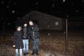
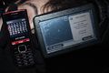
At first we drove to the right place, but on the wrong side of the concrete fence. Then we tried to approach it from the other side, but we couldn't find a good way. We were getting quite desperate as it was cold and sleeting. Finally we have found the right road and managed to reach the required longitude. After a few moments of running back and forth on some field in the darkness and regretting not having a simple compass we have found N-S axis and started going north. When we got about 25m away from the hash point we were stopped by a fence. A few seconds later GPS battery died. We went back to the car, warmed up a bit, took our Balls of Steel™ (for juggling), charged the battery and tried again. After finding a good place to jump over the concrete barrier we finally reached our destination.
Photos


The Eyebrow


Sex Geohash Honourable Mention?


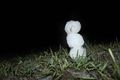
Wee snowman


Achievements