Difference between revisions of "2013-02-01 35 -106"
From Geohashing
imported>Mampfred m |
imported>FippeBot m (Location) |
||
| (One intermediate revision by one other user not shown) | |||
| Line 12: | Line 12: | ||
* [[User:Olyssis|Olyssis]] | * [[User:Olyssis|Olyssis]] | ||
| − | |||
== Plans == | == Plans == | ||
| Line 40: | Line 39: | ||
[[Category:Coordinates not reached]] | [[Category:Coordinates not reached]] | ||
[[Category:Not reached - No public access]] | [[Category:Not reached - No public access]] | ||
| + | {{location|US|NM|ST}} | ||
Latest revision as of 00:52, 14 August 2019
| Fri 1 Feb 2013 in 35,-106: 35.4950848, -106.1627794 geohashing.info google osm bing/os kml crox |
Location
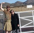
Near Santa Fe, unfortunately on the private property of a quarry. So we didn't make it to the exact spot. : (
Participants
Plans
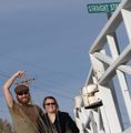
We decided to go from Albuquerque on the East side of the Sandias and travel up North 14. We had lunch and some drinks in Madrid and then traveled through Los Cerrillos to get to the dirt road "Waldo Canyon Rd." to the gate of the quarry where we stopped and took our failure pictures.
Pictures
Achievements
Olyssis earned the No trespassing consolation prize
|

