Difference between revisions of "2013-03-13 54 -3"
imported>Alexandersmith (→Tracklog) |
imported>Alexandersmith (→Photos) |
||
| Line 38: | Line 38: | ||
Image:2012-##-## ## ## Alpha.jpg | Witty Comment | Image:2012-##-## ## ## Alpha.jpg | Witty Comment | ||
--> | --> | ||
| − | <gallery perrow=" | + | <gallery perrow="3"> |
| + | Image:20130313_GeohashAchieved.jpg | Droid Geohash app showing my proximity to the geohash point. | ||
| + | Image:20130313_GeohashAutoPhoto.jpg | Auto-photo at the geo-hash. | ||
| + | Image:20130313_GeohashGeneralLocation.jpg | The general nature of the location. Note the phone in the lower left, this marks the location of the hash. | ||
</gallery> | </gallery> | ||
Revision as of 21:35, 13 March 2013
| Wed 13 Mar 2013 in 54,-3: 54.1101594, -3.1948311 geohashing.info google osm bing/os kml crox |
Location
The location was behind a housing estate in Rampside, Barrow-in-Furness.
Participants
Plans
The plan was to cycle to the hash, and to return home via the same route. Only a 7 mile round trip, and should not present any dramas.
Expedition
I cycled through the busy tea-time afternoon traffic, arrived on site about ten minutes early. Nobody else was present when I arrived. I found the location quickly, as the local terrain was a reasonably well-kept green space surrounding a children's play area. My hopes were raised for a moment when a man with his dog arrived. They didn't show any interest in what I was doing, so I will assume he was not geo-hashing. I waited until 4pm, nobody else arrived, so I left and cycled home.
Tracklog
No tracklog for this journey, I don't qualify for the Tron Achievement.
Photos
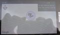
Droid Geohash app showing my proximity to the geohash point.

Auto-photo at the geo-hash.
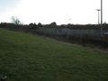
The general nature of the location. Note the phone in the lower left, this marks the location of the hash.


Achievements