Difference between revisions of "2013-03-27 39 -77"
From Geohashing
imported>OfficeLinebacker (→Location) |
imported>OfficeLinebacker (→Expedition) |
||
| Line 32: | Line 32: | ||
| − | *Heading there now -- [[User:OfficeLinebacker|OfficeLinebacker]] ([[User talk:OfficeLinebacker|talk]]) [http://www.openstreetmap.org/?lat=39.09299307&lon=-77.15537045&zoom=16&layers=B000FTF @39.0930, | + | *Heading there now -- [[User:OfficeLinebacker|OfficeLinebacker]] ([[User talk:OfficeLinebacker|talk]]) [http://www.openstreetmap.org/?lat=39.09299307&lon=-77.15537045&zoom=16&layers=B000FTF @39.0930,me roght to the spot.77.1554] 09:58, 27 March 2013 (EDT) |
| + | |||
| + | Drove a ways on a muddy dirt track. Long grasses an stems tickled the undercarriage of my car. Hed to gun it through a couple of deep mud puddles. Once I parked, a deer path led me right to the spot. | ||
| + | |||
== Tracklog == | == Tracklog == | ||
<!-- if your GPS device keeps a log, you may post a link here --> | <!-- if your GPS device keeps a log, you may post a link here --> | ||
Revision as of 18:17, 27 March 2013
| Wed 27 Mar 2013 in 39,-77: 39.5357028, -77.1074312 geohashing.info google osm bing/os kml crox |
Location
In a thicket near a quarry
Participants
Plans
Expedition
- Heading there now -- OfficeLinebacker (talk) @39.0930,me roght to the spot.77.1554 09:58, 27 March 2013 (EDT)
Drove a ways on a muddy dirt track. Long grasses an stems tickled the undercarriage of my car. Hed to gun it through a couple of deep mud puddles. Once I parked, a deer path led me right to the spot.
Tracklog
Photos

Dilly grin @39.5357,-77.1074
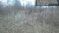
The spot @39.5357,-77.1074
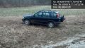
My trusty steed @39.5356,-77.1072
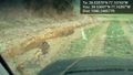
Part of the road there @39.5370,-77.1040


Achievements