Difference between revisions of "2013-03-30 39 -78"
From Geohashing
imported>OfficeLinebacker ([live picture] Murka [http://www.openstreetmap.org/?lat=39.29041525&lon=-78.08713068&zoom=16&layers=B000FTF @39.2904,-78.0871]) |
imported>OfficeLinebacker ([live picture] Denied! [http://www.openstreetmap.org/?lat=39.29041887&lon=-78.08715065&zoom=16&layers=B000FTF @39.2904,-78.0872]) |
||
| Line 42: | Line 42: | ||
Image:2013-03-30_39_-78_19-00-06-364.jpg | Murka [http://www.openstreetmap.org/?lat=39.29041525&lon=-78.08713068&zoom=16&layers=B000FTF @39.2904,-78.0871] | Image:2013-03-30_39_-78_19-00-06-364.jpg | Murka [http://www.openstreetmap.org/?lat=39.29041525&lon=-78.08713068&zoom=16&layers=B000FTF @39.2904,-78.0871] | ||
| + | |||
| + | Image:2013-03-30_39_-78_19-00-30-371.jpg | Denied! [http://www.openstreetmap.org/?lat=39.29041887&lon=-78.08715065&zoom=16&layers=B000FTF @39.2904,-78.0872] | ||
</gallery> | </gallery> | ||
Revision as of 23:00, 30 March 2013
| Sat 30 Mar 2013 in 39,-78: 39.3109856, -78.0758843 geohashing.info google osm bing/os kml crox |
Location
In the woods about 500 feet from the northbound side of Route 81 in Bunker Hill West Virginia
Participants
OfficeLinebacker (talk)OfficeLinebacker
Plans
Expedition
Tracklog
Photos
Murka @39.2904,-78.0871
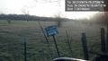
Denied! @39.2904,-78.0872


Achievements