Difference between revisions of "2013-03-30 39 -78"
From Geohashing
imported>Jiml m (Adjust result codes) |
imported>OfficeLinebacker (→Expedition) |
||
| Line 30: | Line 30: | ||
== Expedition == | == Expedition == | ||
<!-- how it all turned out. your narrative goes here. --> | <!-- how it all turned out. your narrative goes here. --> | ||
| + | This was a failed expedition. I thought we could pull off the highway and go a few hundred feet into the brush but there was a fence. I spied a dirt road leading to within a few hundred feet on the other side so we made a U-turn and got off the highway. Once we got to the dirt road, there was a gate and a no-trespassing sign. DE-NIED. | ||
== Tracklog == | == Tracklog == | ||
Revision as of 16:23, 31 March 2013
| Sat 30 Mar 2013 in 39,-78: 39.3109856, -78.0758843 geohashing.info google osm bing/os kml crox |
Location
In the woods about 500 feet from the northbound side of Route 81 in Bunker Hill West Virginia
Participants
Plans
Expedition
This was a failed expedition. I thought we could pull off the highway and go a few hundred feet into the brush but there was a fence. I spied a dirt road leading to within a few hundred feet on the other side so we made a U-turn and got off the highway. Once we got to the dirt road, there was a gate and a no-trespassing sign. DE-NIED.
Tracklog
Photos
Murka @39.2904,-78.0871
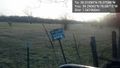
Denied! @39.2904,-78.0872


Achievements
- No trespassing