Difference between revisions of "2013-03-30 39 -78"
From Geohashing
imported>OfficeLinebacker (→Expedition) |
imported>FippeBot m (Location) |
||
| (4 intermediate revisions by 3 users not shown) | |||
| Line 1: | Line 1: | ||
| − | |||
| − | |||
| − | |||
| − | |||
| − | |||
| − | |||
| − | |||
| − | |||
| − | |||
| − | |||
{{meetup graticule | {{meetup graticule | ||
| lat=39 | | lat=39 | ||
| Line 50: | Line 40: | ||
<!-- Add any achievement ribbons you earned below, or remove this section --> | <!-- Add any achievement ribbons you earned below, or remove this section --> | ||
| − | + | {{No trespassing | |
| − | + | | latitude = 39 | |
| − | + | | longitude = -78 | |
| − | + | | date = 2013-03-30 | |
| − | + | | name = OfficeLinebacker | |
| − | + | | image = 2013-03-30_39_-78_19-00-30-371.jpg | |
| + | | distance = 300 ft | ||
| + | }} | ||
[[Category:Expeditions]] | [[Category:Expeditions]] | ||
| Line 63: | Line 55: | ||
[[Category:Coordinates not reached]] | [[Category:Coordinates not reached]] | ||
[[Category:Not reached - No public access]] | [[Category:Not reached - No public access]] | ||
| + | {{location|US|WV|BE}} | ||
Latest revision as of 05:43, 6 August 2019
| Sat 30 Mar 2013 in 39,-78: 39.3109856, -78.0758843 geohashing.info google osm bing/os kml crox |
Location
In the woods about 500 feet from the northbound side of Route 81 in Bunker Hill West Virginia
Participants
Plans
Expedition
This was a failed expedition. I thought we could pull off the highway and go a few hundred feet into the brush but there was a fence. I spied a dirt road leading to within a few hundred feet on the other side so we made a U-turn and got off the highway. Once we got to the dirt road, there was a gate and a no-trespassing sign. DE-NIED.
Tracklog
Photos
Murka @39.2904,-78.0871
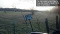
Denied! @39.2904,-78.0872


Achievements
OfficeLinebacker earned the No trespassing consolation prize
|