Difference between revisions of "2013-03-31 38 -77"
From Geohashing
imported>OfficeLinebacker ([live picture] De-nied [http://www.openstreetmap.org/?lat=38.72180552&lon=-77.16256740&zoom=16&layers=B000FTF @38.7218,-77.1626]) |
imported>OfficeLinebacker (→Expedition) |
||
| Line 32: | Line 32: | ||
== Expedition == | == Expedition == | ||
<!-- how it all turned out. your narrative goes here. --> | <!-- how it all turned out. your narrative goes here. --> | ||
| + | We headed down to Ft. Belvoir and followed directions. We arrived at the "Kingman Gate" and the signs indicated that guests are allowed M-F but not on weekends. I took a pic and we headed back. | ||
| + | |||
| + | The geohash was located on an Army base with no public access on weekends. | ||
== Tracklog == | == Tracklog == | ||
Revision as of 23:24, 31 March 2013
| Sun 31 Mar 2013 in 38,-77: 38.7312575, -77.1379917 geohashing.info google osm bing/os kml crox |
Location
About 200 feet into the woods off of John J Kingman road in Fort Belvoir Virginia
Participants
- OfficeLinebacker
- Allison
Plans
Expedition
We headed down to Ft. Belvoir and followed directions. We arrived at the "Kingman Gate" and the signs indicated that guests are allowed M-F but not on weekends. I took a pic and we headed back.
The geohash was located on an Army base with no public access on weekends.
Tracklog
Photos
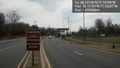
De-nied @38.7218,-77.1626

Achievements