Difference between revisions of "2013-03-31 38 -77"
From Geohashing
imported>OfficeLinebacker ([live] About 200 feet into the woods off of John J Kingman road in Fort Belvoir Virginia) |
imported>FippeBot m (Location) |
||
| (9 intermediate revisions by 3 users not shown) | |||
| Line 15: | Line 15: | ||
}} | }} | ||
| − | + | ||
__NOTOC__ | __NOTOC__ | ||
== Location == | == Location == | ||
| − | + | ||
| + | About 200 feet into the woods off of John J Kingman road in Fort Belvoir Virginia | ||
== Participants == | == Participants == | ||
<!-- who attended: If you link to your wiki user name in this section, your expedition will be picked up by the various statistics generated for geohashing. You may use three tildes ~ as a shortcut to automatically insert the user signature of the account you are editing with. | <!-- who attended: If you link to your wiki user name in this section, your expedition will be picked up by the various statistics generated for geohashing. You may use three tildes ~ as a shortcut to automatically insert the user signature of the account you are editing with. | ||
--> | --> | ||
| + | * [[User:OfficeLinebacker|OfficeLinebacker]] | ||
| + | * Allison | ||
== Plans == | == Plans == | ||
| Line 29: | Line 32: | ||
== Expedition == | == Expedition == | ||
<!-- how it all turned out. your narrative goes here. --> | <!-- how it all turned out. your narrative goes here. --> | ||
| + | We headed down to Ft. Belvoir and followed directions. We arrived at the "Kingman Gate" and the signs indicated that guests are allowed M-F but not on weekends. I took a pic and we headed back. | ||
| + | The geohash was located on an Army base with no public access on weekends. | ||
| − | |||
== Tracklog == | == Tracklog == | ||
<!-- if your GPS device keeps a log, you may post a link here --> | <!-- if your GPS device keeps a log, you may post a link here --> | ||
| Line 40: | Line 44: | ||
--> | --> | ||
<gallery perrow="5"> | <gallery perrow="5"> | ||
| + | |||
| + | Image:2013-03-31_38_-77_10-24-54-564.jpg | De-nied [http://www.openstreetmap.org/?lat=38.72180552&lon=-77.16256740&zoom=16&layers=B000FTF @38.7218,-77.1626] | ||
</gallery> | </gallery> | ||
| Line 45: | Line 51: | ||
{{#vardefine:ribbonwidth|800px}} | {{#vardefine:ribbonwidth|800px}} | ||
<!-- Add any achievement ribbons you earned below, or remove this section --> | <!-- Add any achievement ribbons you earned below, or remove this section --> | ||
| − | + | {{No trespassing | |
| − | + | | latitude = 38 | |
| − | + | | longitude = -77 | |
| − | + | | date = 2013-03-31 | |
| − | + | | name = OfficeLinebacker | |
| − | + | | image = 2013-03-31_38_-77_10-24-54-564.jpg | |
| − | + | | distance = 1.4 miles | |
| − | + | }} | |
| − | |||
| − | |||
| − | |||
| − | |||
[[Category:Expeditions]] | [[Category:Expeditions]] | ||
| − | |||
[[Category:Expeditions with photos]] | [[Category:Expeditions with photos]] | ||
| − | |||
| − | |||
| − | |||
| − | |||
| − | |||
| − | |||
| − | |||
| − | |||
| − | |||
[[Category:Coordinates not reached]] | [[Category:Coordinates not reached]] | ||
| − | |||
| − | |||
| − | |||
| − | |||
| − | |||
[[Category:Not reached - No public access]] | [[Category:Not reached - No public access]] | ||
| − | + | {{location|US|VA|FX}} | |
| − | |||
| − | |||
| − | |||
| − | |||
| − | |||
| − | |||
| − | |||
Latest revision as of 01:41, 14 August 2019
| Sun 31 Mar 2013 in 38,-77: 38.7312575, -77.1379917 geohashing.info google osm bing/os kml crox |
Location
About 200 feet into the woods off of John J Kingman road in Fort Belvoir Virginia
Participants
- OfficeLinebacker
- Allison
Plans
Expedition
We headed down to Ft. Belvoir and followed directions. We arrived at the "Kingman Gate" and the signs indicated that guests are allowed M-F but not on weekends. I took a pic and we headed back.
The geohash was located on an Army base with no public access on weekends.
Tracklog
Photos
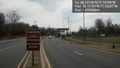
De-nied @38.7218,-77.1626

Achievements
OfficeLinebacker earned the No trespassing consolation prize
|