Difference between revisions of "2013-04-07 53 -2"
imported>Longhairedred (→Photos) |
imported>Longhairedred (→Achievements) |
||
| Line 55: | Line 55: | ||
| − | + | {{land geohash | |
| − | |||
| − | |||
| − | + | | latitude = 53 | |
| − | + | | longitude = -2 | |
| − | + | | date = 2013-04-07 | |
| − | -- | ||
| − | + | }} | |
| − | |||
| − | |||
| − | |||
| − | |||
| − | |||
| − | |||
| − | |||
| − | |||
| − | |||
| − | |||
| − | |||
| − | |||
| − | |||
| − | |||
| − | |||
| − | |||
| − | |||
| − | |||
| − | |||
| − | |||
| − | |||
| − | |||
| − | |||
| − | |||
| − | |||
| − | |||
| − | |||
Revision as of 09:07, 9 April 2013
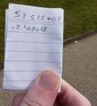
| Sun 7 Apr 2013 in 53,-2: 53.5354031, -2.1080671 geohashing.info google osm bing/os kml crox |
Location
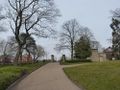
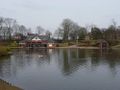
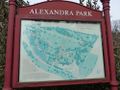
The geohash was just in the northwest corner of Alexandra Park, Oldham.
Participants
- Longhairedred, also two friends who happened to be nearby at the time.
Plans
Expedition
Decided to check today's geohash whilst having my lunch over at a friend's house. Noticed it was just down the road (about 20mins if you go straight there). Finished eating and suggested we walk over. I explained it as an adventure generator which does magic stuff with numbers to find a random place. We headed out, albeit with a few detours to explore along the way. Got to the geohash around 13:45, couldn't find anywhere to leave a marker, so just stood at the geohash and took photos from there in various directions. Then went and bought ice-cream from the boathouse cafe next to the geohash. We then walked around for a bit then walked back to my friend's house. I claimed the photos on my USB drive, walked home, then started writing up. Unfortunately the internet is slow enough that it has taken much longer to write this, than it did to walk to and from the geohash.
Tracklog
Photos
Witty Comment


Achievements
This user earned the Land geohash achievement
|