Difference between revisions of "2013-04-21 47 -117"
From Geohashing
imported>Jiml m (Adjust result codes) |
imported>Jiml m (Adjust to retro) |
||
| Line 4: | Line 4: | ||
| date=2013-04-21 | | date=2013-04-21 | ||
| graticule_name=Spokane | | graticule_name=Spokane | ||
| − | | graticule_link=Spokane, Washington | + | | graticule_link=Spokane, Washington |
| + | | retro=1 | ||
}} | }} | ||
| Line 33: | Line 34: | ||
</gallery> | </gallery> | ||
| − | [[Category: | + | [[Category:Retro meetup]] |
[[Category:Expeditions with photos]] | [[Category:Expeditions with photos]] | ||
| − | [[Category: | + | [[Category:Retro coordinates reached]] |
Revision as of 04:51, 20 April 2013
| Sun 21 Apr 2013 in Spokane: 47.6455865, -117.3601992 geohashing.info google osm bing/os kml crox |
Location
On the grounds of the Bethel Church of the Nazarene, East Spokane
Participants
Plans
Leaving town in the morning - might shoot for a Sunday after-midnight visit.
Expedition
- Holy hash parking for Sunday. -- Thomcat (talk) @47.6451,-117.3602 18:46, 19 April 2013 (PDT)
- Hi from Holy Ground! -- Thomcat (talk) @47.6456,-117.3602 18:51, 19 April 2013 (PDT)
Photos
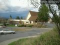
The holy ground of record @47.6450,-117.3606
