Difference between revisions of "2013-05-04 39 -77"
From Geohashing
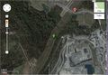
imported>OfficeLinebacker ([live picture] Silly grin [http://www.openstreetmap.org/?lat=39.08310495&lon=-77.52363122&zoom=16&layers=B000FTF @39.0831,-77.5236]) |
imported>OfficeLinebacker ([live picture] A small stream nearby [http://www.openstreetmap.org/?lat=39.08452262&lon=-77.52322803&zoom=16&layers=B000FTF @39.0845,-77.5232]) |
||
| Line 45: | Line 45: | ||
Image:2013-05-04_39_-77_16-13-51-304.jpg | Silly grin [http://www.openstreetmap.org/?lat=39.08310495&lon=-77.52363122&zoom=16&layers=B000FTF @39.0831,-77.5236] | Image:2013-05-04_39_-77_16-13-51-304.jpg | Silly grin [http://www.openstreetmap.org/?lat=39.08310495&lon=-77.52363122&zoom=16&layers=B000FTF @39.0831,-77.5236] | ||
| + | |||
| + | Image:2013-05-04_39_-77_16-18-00-536.jpg | A small stream nearby [http://www.openstreetmap.org/?lat=39.08452262&lon=-77.52322803&zoom=16&layers=B000FTF @39.0845,-77.5232] | ||
</gallery> | </gallery> | ||
Revision as of 20:17, 4 May 2013
| Sat 4 May 2013 in 39,-77: 39.0831226, -77.5235966 geohashing.info google osm bing/os kml crox |
Location
- In a mowed track under some power lines in Leesburg Virginia
Participants
Plans
We are planning on going at around 4pm Eastern US time, and may try to live stream the expedition via TinyChat again, if there are any interested viewers.
Expedition
Tracklog
Photos
The satellite view @39.0931,-77.1554

Silly grin @39.0831,-77.5236
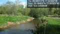
A small stream nearby @39.0845,-77.5232


Achievements